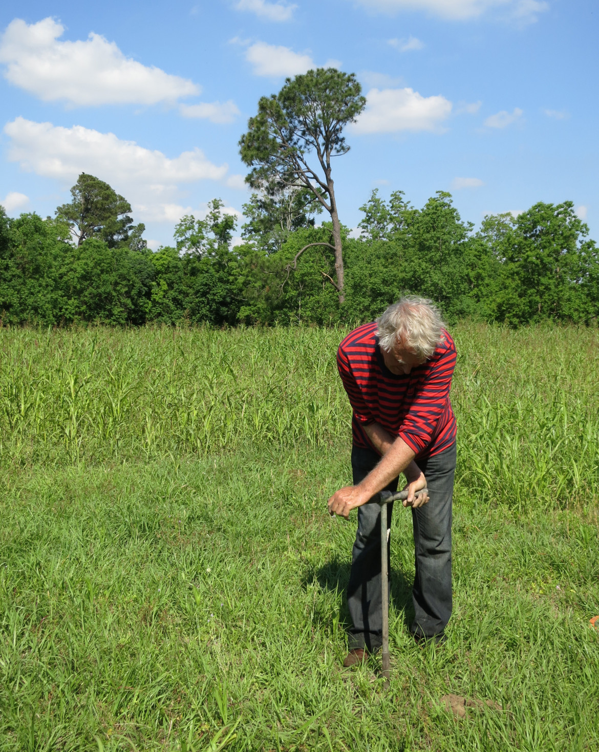
Roelof Stuurman uses a hand auger to drill a hole for an experimental groundwater monitoring gauge near Mirabeau Ave. Hydrologists say the city needs a system of such gauges before the city can address is serious subsidence issues.
Roelof Stuurman uses a hand auger to drill a hole for an experimental groundwater monitoring gauge near Mirabeau Ave. Hydrologists say the city needs a system of such gauges before the city can address is serious subsidence issues. Credit: Photo by Ramiro Diaz

On a warm and muggy  morning, architectural designer Ramiro Diaz is twisting a hand auger — a length of 1-inch iron pipe — into the New Orleans soil behind the Healing Center on St. Claude Avenue. About 2 feet into the sweaty job, the auger comes up with the sucking sound of a boot pulling out of swamp mud. Water drips from the gray clay encasing the bottom of the probe.

“Look at that,  just 70 centimeters [27.5 inches] down and we’re in water,” he says. “But just a mile from here, it might be 4 feet down or 7 – or less than 2 feet,” he says “We should have wells like this monitoring groundwater across the metro area, but we don’t.

“It’s really a serious failure because this is critical information for our future.”

For a city struggling to address some very visible problems – poorly performing schools, high crime and poverty rates  – worrying about what’s happening out of sight might sound superfluous. But civic leaders and public officials increasingly are aware that this issue can no longer be ignored.

Perched on the edge of the Mississippi River delta in the heart of Hurricane Alley, New Orleans leaders believed for 300 years that the city’s safety lay in draining the soggy mud sponge it was built on. But as that sponge drained, it also shrank, steadily pulling most of the city below sea level, a process that continues today. The result has been increasing flood risk from rain and hurricanes, and billions in ongoing repairs to sunken homes and crumbling streets.

In the past few years, officials have learned the best way to control the costly physical damage roiling its surface is by keeping that sponge below the surface hydrated.

One of the first steps in reaching that goal, city officials and civic leaders say, is finding a way to monitor what’s happening below.

Although there is no system now endorsed by the city, a blueprint for one is contained in the Greater New Orleans Urban Water Plan, an ambitious, $9 billion wishlist unveiled in 2013 by civic leaders at the urging of the state. It would employ a suite of remedies from the simple ( rain barrels) to the extreme (reworking the city’s entire drainage system). The program isn’t close to being funded, but planners are taking small steps, including drilling some monitoring wells.

In an ideal world, New Orleans would be able to control water levels as quickly and easily as a bather adjusts tub water. Keep it within 2 to 3 feet of the surface most of the time to reduce subsidence, then quickly draw it down when heavy rains or hurricanes are approaching.

A patchwork of underground water

But nothing is ideal about the land beneath this city. What appears simple at first glance presents a Rubik’s Cube of challenges for engineers trying to solve the problem.

In fact, the very term “water table” seems inappropriate when talking about New Orleans. After all, tables are flat, uniform and – above all – level. None of those descriptions applies to the delta soils which control ground water beneath the city.

Because the metro area sits on a delta laid down by varying degrees of river floods over thousands of years, there is no uniformity of soil types either horizontally across its 1,907 square miles or vertically through its 150 feet to the first bedrock. Homes may rest on impervious clays in one neighborhood but sieve-like sands or spongy peats in the next, each of which holds and drains water at different rates. And those layers may change every few feet the deeper one digs.

That weave of soil types produces a water table that is never uniform.

Understanding that soil profile is the first ground rule for engineers trying to address subsidence. The second is finding a way to keep those soils moist using a high water table without reducing the city’s ability to quickly pump out the sudden 1- to 3-inch rainfalls that often flood streets, cars and homes.
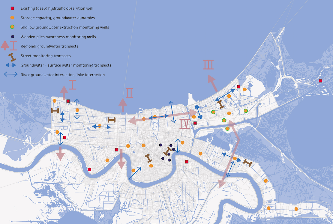
This map from the Urban Water Plan for New Orleans  shows how water moves underground and where experts think we should place monitoring wells.
This map from the Urban Water Plan for New Orleans shows how water moves underground and where experts think we should place monitoring wells. Credit: Courtesy of the Greater New Orleans Water Plan.

The Urban Water Plan lays out a path to that compromise. Since there is no way to quickly drain the water table to make room for a sudden rainstorm, the plan proposes creating surface storage for water. Modified canals usually kept dry could remain filled, and empty lots could be turned into rain gardens. The sides and bottoms of those facilities could be made to let water slowly seep into the ground, keeping the water table more stable. They could also be quickly drained before a rainstorm, creating space to store the deluge.

“It all goes hand-in-hand,” said David Waggonner, an architect and co-author of the plan. “You can’t address the groundwater-level issues without addressing surface storage and your stormwater-drainage system.”

To do this, drainage workers have to know how full the sponge is.

“You can’t manage what you don’t measure,” said Roelof Stuurman, a Dutch groundwater specialist and co-author of the Groundwater Monitoring Network proposal in the Urban Water Plan.

A relatively simple system needed for New Orleans

Groundwater monitor wells typically are small-diameter borings drilled into soils. A plastic pipe is dropped into the hole containing instruments that can keep a record of the water level. Ideally the wells are wirelessly connected to a computer system providing a daily record of the rise and fall of the groundwater level, as well as other measurement such a salinity levels.

Some communities elsewhere in the country that depend on groundwater for drinking or agriculture have networks that employ hundreds of wells.

Because New Orleans gets its drinking water from the river, Stuurman designed a scaled-down version for the metro area, using about 40 wells at an estimated initial cost of around $300,000 and annual operational expenses around $22,000.  It would provide metro officials a real time picture on:

  •   Basic groundwater levels, the key factor in subsidence rates in most areas.
  •   Where and at what volumes water moves underground from one part of the area to the next – information important to storm-water drainage plans.
  •   The effects changing groundwater levels and subsidence are having on the wooden pilings supporting many of the city’s buildings and homes – an issue brought to light in other cities.
  •   The interactions between the river and lake on the city’s groundwater.
  •   Where and how much groundwater is being extracted by industries, an issue that could be a factor in subsidence rates.
  •   Basic water quality information, particularly if the water  is becoming saltier as the region sinks and the Gulf of Mexico rises due to global warming.

Most of the wells would be concentrated in areas that have the greatest subsidence potential. This generally means neighborhoods resting on organic soils, such as peat, which decompose and shrink when dry at a much faster rate than soils composed primarily of clays and sands.

The information provided by the monitoring network could direct groundwater management efforts as well identify areas of greatest need.

Cedric Grant, executive director of the Sewerage & Water Board of New Orleans, said the city supports the move to green infrastructure in the drainage system.

“Not only can it address some of our subsidence problems, but it can also help slow down the rate at which water enters our drainage system, which can help relieve the pumps from being overwhelmed,” he said.

He said he hopes to secure federal money to pay for a groundwater monitoring network in the next 12 months. However, if that funding come through, he said “we would be willing to move forward on a network without them.”

From 2013 to 2017, Bob Marshall covered environmental issues for The Lens, with a special focus on coastal restoration and wetlands. While at The Times-Picayune, his work chronicling the people, stories...

13 replies on “Water and subsidence: “You can’t manage what you don’t measure””

  1. Bob,

    Thanks for another great article. Everyone in the city should read the Urban Water Plan. It is a tremendous document. The only thing I would add to it would be a recommendation to understand the broader aspects of subsidence that are affecting the city.

    https://www.dropbox.com/s/yc8s5zhqgwx2y4i/Subsidence%20in%20New%20Orleans%20East.pdf?dl=0

    Geologic faults are probably controlling much of the subsidence that is occurring outside of the levees. The more we understand about them, the better we will be able to plan for flood protection.

  2. When covering water issues in New Orleans we must always consider the inevitable severe storms such as Katrina or even stronger and greater storm surge. The Urban Water Plan ignores that risk and is only concerned with 3″ rainfall or less.

    This position is of particular concern given that Katrina was not the worst case we might have experienced. If we had experienced the same 30’+ surge as Mississippi, all our flood walls and levees would have been overtopped with a significant chance of catastrophic collapse.

    The most significant aspect of global conditions is not an increase in the number of storms but the increased likelihood of unprecedented extreme storms. The Urban Water Plan ignores or worse, dismisses extreme storms as the major existential risk to our city.

    New Orleans has a considerable shoring and elevation industry to address subsidence as and when it occurs. What is more important is setting a “realistic” flood elevation based on our storm of record “coffee stains” which would be 4-5′ higher than the present BFE. Using the 100 year storm has been thuroughly and repeatedly rejected by the National Academy of Science which includes the Corps of Engineers.

  3. Every 404/wetlands delineator has a hand auger. We’ve used ours on thousands of acres, in and out of levees, in and out of New Orleans. There’s nothing the slightest bit unusual about hitting boot-sucking soils where water is only a few inches below the surface. In fact, in places with “coffee grounds” inside Orleans Parish (inside levees), the water table can be a few inches down one day and the next day be 2 feet down. Once formerly hydric soil converts, it doesn’t plump back up again, no matter how much rain it gets, That’s how you get “walking trees,” where they are perched 2-3-4 feet in the air, on their roots.
    Don’t forget the USDA soil surveys. Louisiana has been mapped for over a century and the latest editions have been digital and on-line for, what, 8 years now? A lot of this can be first order done remotely, but there’s no substitute for ground truthing.

  4. The flooding in New Orleans that results from overtopping of the levees is as more a function of the depth of the “bowl” that we have created in the city than anything else. The city is underlain by a subsided barrier island chain that supports the Metairie and Gentilly Ridges (where the effects of flooding were less). On either side of this Pine Island ridge of sand are thick layers of organic peat soils. Since we have isolated the city from the surrounding bodies of water, and engaged in a water plan that seeks to keep the level of the canals down and move water off the landscape of quickly as possible, we have caused these peat layers to desiccate and oxidize. In other words the substrate under much of the city is drying and decaying out from under our feet. If this continues, the elevation of the bottom of the bowl will continue to drop.
    The Urban Water Plan offers a rational and achievable method to keep the organic peats hydrated and to slow the rate of subsidence that their decay has causes. By keeping more water in the canals, and reducing the rate at which the surface drainage systems move water into them, be can prevent the peats from decaying at the accelerated rates that they have been, and still move water out of the city at the same rate we did in the past.
    The Plan is not antithetical to raising the elevation of the levees in any way. It is simply a means to slow the rate at which they are sinking.

  5. “Thank Gawd of the Lower Ninth Ward” for people like Kelly M. Haggar, KC King, and Chris McLindon. I wants them on my flatboat when WE (yeah ASP, you is with me, Boy) leave this gawd4saken coffee grounds city and move to higher ground. 07/08/2015 2:31 AM DST USA

  6. “Leave the city” is two or three hornet’s nests worth of hassle & buzz. New Orleans the city is 300 years old; the land forming Orleans Parish is maybe 3,000 years old. Orleans and Jefferson and Da Parish were not always here . . . and they won’t always be here. Chris has done a really great job of not only breaking out and coloring the last 16 deltas from Frazier 1967 but has also related them to structure. Right now the active delta is shifting west, to the Lower Atch & Wax Lake Outlet. The fading Balize Delta will become the Balize Barrier Islands and then as they continue to sink they will become the Balize Shoals. It’s like the opening narration of Disney’s Peter Pan (1952) . . . “All this has happened before, and will happen again.”
    But “when” is a different question. The late Roy Dokka (LSU prof) thought New Orleans East had a slow motion earthquake lasting 25 years; 1970-1995. That was merely fault movement; they are episodic. Crustal deformation is more a slow and steady thing. The transforms play 20 or 30 miles down. (Bedrock under the city at 150 feet – – that’s a new one on me. Curious about the source of that number.) I’m not believing “the basement” is either at -10 meters nor that it is “stable.” In fact, the relative motion of CORS stations tells us S La is not only sinking at triple the rate the ocean is rising but it is also headed about 170 degrees true (almost due south) while most of the state is headed west (270 true).
    In any event, there’s more than enough time to panic. New Orleans will not become an island on the end of a causeway for many decades; perhaps not for more than a century. Provided our grandchildren rise above the idea that engineers have an adequate supply of pixie dust (or clay), they have time to adapt to the inevitable . . . while those of voting age inside the city now seem to have convinced themselves they need do no more than support the Master Plan.

  7. Way to go, “Kelly M. Haggar.” ASP and me – we was ordered to LEAVE by the ARMY after Katrina. Talk about being bullied – at gunpoint yet! Ha! WE didn’t like that and WE sure as hell didn’t appreciate being told to get out or else WE was going to be “TAKEN OUT.” Me and my ASP don’t like the “M” word – MANDATORY – In fact, it makes us want to do the opposite. LMAspO! 07/08/2015 2:38 PM DST USA

  8. By the time you find yourself enmeshed in the whole field of “disaster law,” I submit you are obviously WELL beyond planning measures, monitoring wells, or listening to the Dutch on any topic. N’cest pas?

  9. Hahaha! You are one of the very few remaining good guys. You have submitted correctly, “Kelly M. Haggar.” We appreciate all of the very knowledgeable and detailed information you have shared with us. Danke, Freund! Verstehen Sie?
    ASP and I plan to co-enroll in conversational Russian. BTW, WE love the Dutch, and if the U.S. wasn’t so (expletive deleted), we could learn a lot from them. WE don’t like that the Chinese own one of four hogs raised in the U.S. We don’t like to plan unless forced to do so. Obviously, remaining in the city and watching 99% of the neighbors leave during a mandatory evacuation ordered by Ray Nagin was disheartening, but WE did get to see a lot of “things” post-Katrina that most people did not (and would not want to) see.
    If WE had to do it all over again, WE would, unless somebody tells us WE can’t leave. Then WE will. LMAspO! 07/08/2015 10:02 PM DST USA

  10. Ah yes, “disaster law,” WE are not well versed in it yet, (but have enrolled in a Louisiana education-law fast-track internet course – if it’s good enough for the State Superintendent of Education – well, it’s good enough for us), and what better place to practice but in Louisiana.
    Let’s see how good this works: ” I ARREST my case, Yo’ Honore’. Yes, I stands on da First, plead da Fifth, and requestes dat one psychiatrist dat found Benson incompetent to conduct his own business.”
    I got more (precedents), but am saving them for the appeal. WE are going to highlight the subliminal “passages” and sneak them in – just like the attorneys used to do in the now-deceased CDC -“RIP” Yada T. Magee’s courtroom. Ha!
    07/09/2015 12:15 AM DST USA

  11. From what I see, it ain’t the “water and subsidence” that’s going to “do us in.”
    07/09/2015 10:31PM DST USA

  12. “YOU NEED TO ANSWER YO’ PHONE.” WE is “going under.” Sound familiar?
    07/10/2015 3:44 AM DST USA

  13. 10 years after Katrina – “Georgia, On My Mind.” Sung so beautifully by Ray Charles. Georgia is certainly on the mind of Harry Connick, Jr.
    Not at home – and certainly not here.
    08/20/2015 6:04 AM DST USA

Comments are closed.