
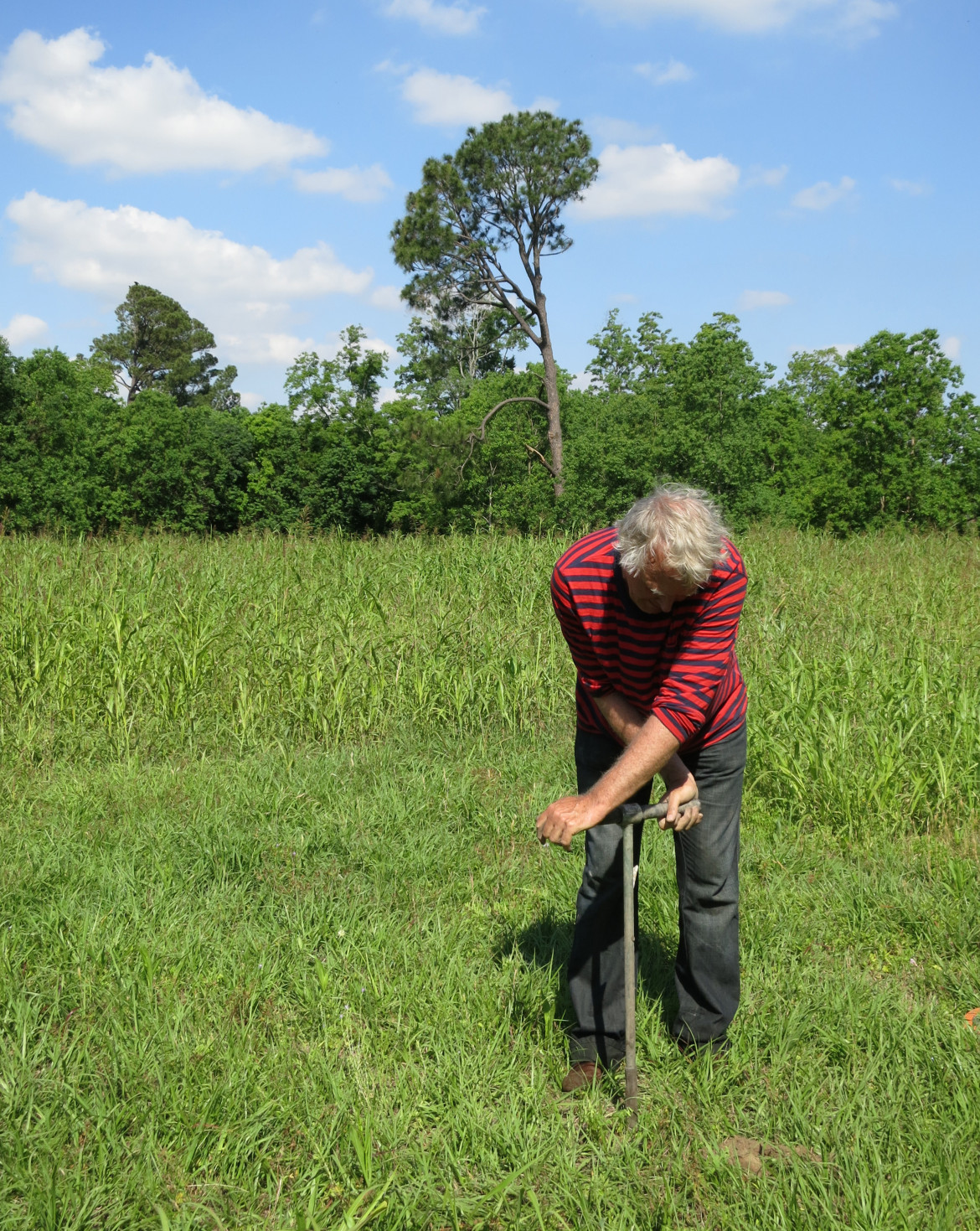
On a warm and muggy morning, architectural designer Ramiro Diaz is twisting a hand auger — a length of 1-inch iron pipe — into the New Orleans soil behind the Healing Center on St. Claude Avenue. About 2 feet into the sweaty job, the auger comes up with the sucking sound of a boot pulling out of swamp mud. Water drips from the gray clay encasing the bottom of the probe.
“Look at that, just 70 centimeters [27.5 inches] down and we’re in water,” he says. “But just a mile from here, it might be 4 feet down or 7 – or less than 2 feet,” he says “We should have wells like this monitoring groundwater across the metro area, but we don’t.
“It’s really a serious failure because this is critical information for our future.”
For a city struggling to address some very visible problems – poorly performing schools, high crime and poverty rates – worrying about what’s happening out of sight might sound superfluous. But civic leaders and public officials increasingly are aware that this issue can no longer be ignored.
Perched on the edge of the Mississippi River delta in the heart of Hurricane Alley, New Orleans leaders believed for 300 years that the city’s safety lay in draining the soggy mud sponge it was built on. But as that sponge drained, it also shrank, steadily pulling most of the city below sea level, a process that continues today. The result has been increasing flood risk from rain and hurricanes, and billions in ongoing repairs to sunken homes and crumbling streets.
In the past few years, officials have learned the best way to control the costly physical damage roiling its surface is by keeping that sponge below the surface hydrated.
One of the first steps in reaching that goal, city officials and civic leaders say, is finding a way to monitor what’s happening below.
Although there is no system now endorsed by the city, a blueprint for one is contained in the Greater New Orleans Urban Water Plan, an ambitious, $9 billion wishlist unveiled in 2013 by civic leaders at the urging of the state. It would employ a suite of remedies from the simple ( rain barrels) to the extreme (reworking the city’s entire drainage system). The program isn’t close to being funded, but planners are taking small steps, including drilling some monitoring wells.
In an ideal world, New Orleans would be able to control water levels as quickly and easily as a bather adjusts tub water. Keep it within 2 to 3 feet of the surface most of the time to reduce subsidence, then quickly draw it down when heavy rains or hurricanes are approaching.
A patchwork of underground water
But nothing is ideal about the land beneath this city. What appears simple at first glance presents a Rubik’s Cube of challenges for engineers trying to solve the problem.
In fact, the very term “water table” seems inappropriate when talking about New Orleans. After all, tables are flat, uniform and – above all – level. None of those descriptions applies to the delta soils which control ground water beneath the city.
Because the metro area sits on a delta laid down by varying degrees of river floods over thousands of years, there is no uniformity of soil types either horizontally across its 1,907 square miles or vertically through its 150 feet to the first bedrock. Homes may rest on impervious clays in one neighborhood but sieve-like sands or spongy peats in the next, each of which holds and drains water at different rates. And those layers may change every few feet the deeper one digs.
That weave of soil types produces a water table that is never uniform.
Understanding that soil profile is the first ground rule for engineers trying to address subsidence. The second is finding a way to keep those soils moist using a high water table without reducing the city’s ability to quickly pump out the sudden 1- to 3-inch rainfalls that often flood streets, cars and homes.
The Urban Water Plan lays out a path to that compromise. Since there is no way to quickly drain the water table to make room for a sudden rainstorm, the plan proposes creating surface storage for water. Modified canals usually kept dry could remain filled, and empty lots could be turned into rain gardens. The sides and bottoms of those facilities could be made to let water slowly seep into the ground, keeping the water table more stable. They could also be quickly drained before a rainstorm, creating space to store the deluge.
“It all goes hand-in-hand,” said David Waggonner, an architect and co-author of the plan. “You can’t address the groundwater-level issues without addressing surface storage and your stormwater-drainage system.”
To do this, drainage workers have to know how full the sponge is.
“You can’t manage what you don’t measure,” said Roelof Stuurman, a Dutch groundwater specialist and co-author of the Groundwater Monitoring Network proposal in the Urban Water Plan.
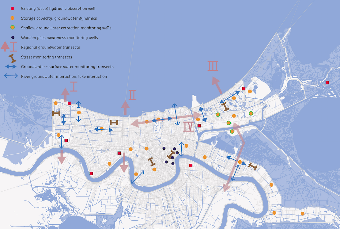
A relatively simple system needed for New Orleans
Groundwater monitor wells typically are small-diameter borings drilled into soils. A plastic pipe is dropped into the hole containing instruments that can keep a record of the water level. Ideally the wells are wirelessly connected to a computer system providing a daily record of the rise and fall of the groundwater level, as well as other measurement such a salinity levels.
Some communities elsewhere in the country that depend on groundwater for drinking or agriculture have networks that employ hundreds of wells.
Because New Orleans gets its drinking water from the river, Stuurman designed a scaled-down version for the metro area, using about 40 wells at an estimated initial cost of around $300,000 and annual operational expenses around $22,000. It would provide metro officials a real time picture on:
- Basic groundwater levels, the key factor in subsidence rates in most areas.
- Where and at what volumes water moves underground from one part of the area to the next – information important to storm-water drainage plans.
- The effects changing groundwater levels and subsidence are having on the wooden pilings supporting many of the city’s buildings and homes – an issue brought to light in other cities.
- The interactions between the river and lake on the city’s groundwater.
- Where and how much groundwater is being extracted by industries, an issue that could be a factor in subsidence rates.
- Basic water quality information, particularly if the water is becoming saltier as the region sinks and the Gulf of Mexico rises due to global warming.
Most of the wells would be concentrated in areas that have the greatest subsidence potential. This generally means neighborhoods resting on organic soils, such as peat, which decompose and shrink when dry at a much faster rate than soils composed primarily of clays and sands.
The information provided by the monitoring network could direct groundwater management efforts as well identify areas of greatest need.
Cedric Grant, executive director of the Sewerage & Water Board of New Orleans, said the city supports the move to green infrastructure in the drainage system.
“Not only can it address some of our subsidence problems, but it can also help slow down the rate at which water enters our drainage system, which can help relieve the pumps from being overwhelmed,” he said.
He said he hopes to secure federal money to pay for a groundwater monitoring network in the next 12 months. However, if that funding come through, he said “we would be willing to move forward on a network without them.”

