If you thought sinking land and rising seas were the only things we had to worry about in south Louisiana, think again.
Tsunamis have now joined the list.
Researchers with the National Weather Service say a 15-foot wall of water could roll across Grand Isle if a landslide occurred in the Mississippi Canyon, a trench in the Gulf of Mexico floor about 30 miles off the mouth of the Mississippi River.
And unlike a hurricane, residents would have just an hour’s notice, not days.
Such landslides have happened about once every 1,000 years in that area – and that time frame is almost up.
“It should be stressed that it is a low probability event — one in a thousand — but it still is a credible event, and would be of a high impact,” said Joe Rua, the lead forecaster and Tsunami Program Manager for the Lake Charles office of the National Weather Service.
The National Weather Service directed its coastal offices to investigate tsunami possibilities after the devastating 2004 Indian Ocean tsunami. Rua said his team found evidence of previous slides in the canyon, which could cause significant tsunamis.
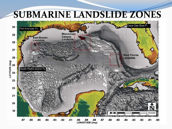
The hypothetical landslide used in National Weather Service computer model was 13 miles wide, 40 miles long and dumped enough rocks and sediment into the canyon to fill 38 Superdomes. The Gulf is more than 7,000 feet deep at the edge of the canyon, which is another 300 feet deep at the site in the model.
“Basically, the material falling into the canyon would displace the water that is already there, and that would cause the wave,” Rua said. “It wouldn’t be very noticeable in the open Gulf, but as the wave reached the shallower water near the shore, it would rise up.
“We estimate it would be about 14 to 15 feet [high] at Grand Isle, 10.5 feet in St. Mary Parish, and about 4 feet in Cameron Parish.”
The height of the tsunami would drop quickly as it moved inshore, due to friction from the land. Rua said a 10.5-foot wave entering the Atchafalaya delta would only be 5 feet by the time it reached Morgan City.
“A hurricane’s storm surge doesn’t drop as quickly because the energy behind it — the storm — is moving with it,” Rua said. “The tsunami doesn’t have that. Once it hits land, it loses energy rapidly.”
The likely trigger of a future slide would be seismic activity, which has been rare in this area; the eruption of large gas bubbles through the sediment layers at the base of the area; or the sheer weight of the sediment resting on the edge of the canyon.
Rua said more modeling has to be done to fine-tune the results. The purpose of the exercise was to alert communities to tsunami risk so they could prepare for the possibility in case “this once-in-a-lifetime event occurs.”
“Basically, we will probably only have one chance to get it right, and there won’t be a do-over,” he said.
The GoM area is somewhat seismically active. Extensive faulting is one of the things that’s allowed for large hydrocarbon accumulation.
Also, subsea mudslides caused by Katrina & Rita did extensive damage to pipeline networks in 2005.
Unfortunately, I was not able to view the animation embedded within the NWS presentation
It makes me glad that I live on the north side of the Great Traffic Barrier Wall they just built down the center of I-12 in Slidell. A tsunami knocks that down, and New Orleans would be mostly gone. Check out the YouTube videos of the Japanese tsunami coming in. They look like a Hollywood disaster epic. Had the Japanese not been so prepared, a couple of hundred thousand people would have been killed. Tokyo is a sitting duck for one someday when that section of the subduction zone snaps. Much of the city is quite low. A massive tsunami could cause catastrophic damage if the water gets forced into Tokyo Bay with nowhere to go.
Whoever is in Louisiana, it’s hard to believe that anyone could find anything to be glad about. O, I am so glad. My house only took on 50 feet of water. O, look at me – I am so lucky. My house – my house – where is my house?!!!
I am not worried by Submarine Landslide Zones, which reminds me of that line in “Butch Cassidy and the Sundance Kid,” when Sundance says, “I can’t swim,” and Butch says, “The fall will kill you.” How else shall I put this? “A wink is the same as a nod to a blind man.” Will/does it matter? If one were to look at the 200-year projection of what the U.S. of A. will look like, it would appear that there is a huge water divide that cuts the U.S. in half (no, not that equal). It’s more like how the Misssissippi flows (the river – not the state).
A landslide causing mega-tsunami (vs. regular tsunami) is also scheduled to occur in the Atlantic when the island of La Palma in the Canary Islands collapses following a vulcan event. Or, as can be seen in my novel, The Wave, if precipitated by humans. Such an event will cause trillions of dollars in damage as a wave rushes across the Atlantic at the speed of a jet plane and destroys everything within 10 or so KM of the coast, from Maine to Miami.
MUDSLIDES AND TSUNAMIS: So, I guess Nostradamus was correct. There will be no SUMMER in 2014. Mr. Smarty in Austin attributes this prediction to either volcanic action or Divine Intervention (DI). But, is it really one or the other? BTW, J.G., you are definitely operating on a higher level! I think that we humans REALLY get the REAL news in what people write about [some may call it fiction and/or fantasy, but I like to think of it as Universal Consciousness (UC) ]. “This is the stuff that dreams are made of.”
Me neither. ;(
This is scaring me real bad.