
Few would doubt that Louisiana needs both economic development and environmental rejuvenation. At Myrtle Grove, a small river town in Plaquemines Parish, those imperatives make for a critical dilemma: whether to put a priority on rebuilding the coastal land that has been melting into the Gulf of Mexico for decades or capitalize on the state’s geo-strategic location and beef up coal export facilities for hungry foreign markets.
Snuggled between the Mississippi River and the wetlands bordering Barataria Bay, Myrtle Grove has been identified by coastal restoration experts as an excellent place for a river sediment diversion. The diversion would allow the river to periodically coat adjacent wetlands with mud-rich water the way it did before levees were built and annual flooding was brought under control. But a coal storage depot proposed by RAM Terminals, LLC, is also planned for the same spot, raising concern that toxins from the coal will damage marsh grasses needed to anchor river silt and eventually build new land.
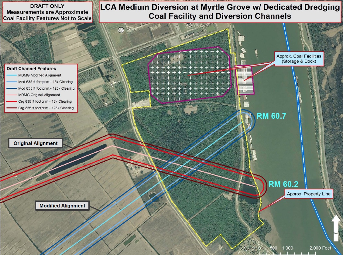
Neither the coal-transfer facility nor the diversion have received final approval or are near construction, but each are at a critical review stage and are affected by the other.
“We desperately need it to work,” Scott Eustis, coastal wetlands specialist at the New Orleans-based Gulf Restoration Network, said of the planned diversion. “We know that sulfides and sulfuric acid from coal runoff can reduce root growth of some marsh plants. The health of these plants is critical to their ability to sustain wetlands that protect Louisiana from storms – which is the very the purpose of the Myrtle Grove project.”
View RAM coal depot in a larger map
A charter boat captain who grew up in New Orleans’ Lakeview neighborhood, Zack Mouton has been operating out of Myrtle Grove since 2001 and fishing and camping on the coast for decades. He said coal dust from other coal handlers in the area is already a fact of life.
“I have to wash my boat every other day,” he said, adding that a walk up the pier to his boat leaves footprints in the film of dust.
That doesn’t make Mouton a dedicated foe of the coal depot, but he has no illusions about the need for a “massive” land-building project.
“Of course it’s going to mess up some of the oyster guys, and it’s going to mess up my fishing … but if you don’t do something, you’ll have nothing in 20 years because the erosion is happening, faster and faster and faster.”
A group of residents from Ironton, a small town near Myrtle Grove are unequivocal in their opposition to the depot. They addressed the Plaquemines Parish Council’s Aug. 23 meeting to complain that officials had not notified them of the permitting process and to argue for an environmental impact study before the depot goes any further.
In a follow-up phone interview with The Lens, Plaquemines Parish Council member Burghart Turner said he has introduced legislation to reverse an April vote by the council, which established its intent to issue revenue bonds in connection with the coal facility.
“I don’t think putting a coal facility right next to you creates a health benefit,” he said, noting that the terminal would also conflict with the state’s Master Plan. Turner, whose district includes Ironton, said there had been discussion of moving the community as well as the diversion, moves he opposes.

reporting partners at WVUE-TV
“The people are far more important than the coal industry,” he said.
Mounds of coal up to 80 feet high will dominate the depot’s 9.7 acres, according to the engineering documents.
Environmentalists have several concerns
Yet coal runoff and dust aren’t the only worries for environmentalists. They also suspect that the barges loading and unloading coal would interfere with the flow of sediment into the diversion and out over the Barataria Bay wetlands. The permit application filed with the Army Corps of Engineers anticipates that, at any one time, four or five four-tier barges might be anchored at or passing by the depot. Five four-tier barges is the equivalent of 200 individual barges, an Army Corps representative explained.
In its Army Corps application, Delaware-registered RAM Terminal said: “We have taken all steps possible to minimize the amount of wetlands that will be impacted. We have positioned the terminal in a way that avoids impacts.”
The application goes on to say that land-bank credits will be used to mitigate “unavoidable impacts.” A permit request filed with the state’s Department of Natural Resources estimated that roughly “191.26 acres of upland and 31.33 acres of non-vegetated waterbottom may be directly impacted by the proposed work.”
Arsenic, polycyclic aromatic hydrocarbons and sulfides are some of the toxins associated with the coal runoff that Eustis sees as a threat to marsh grasses and the efficacy of the state’s wetlands restoration effort.
Garrett Graves, Gov. Bobby Jindal’s appointee as chief of the state’s Coastal Protection and Restoration Authority, said plans for the depot and the diversion remain fluid but that both have their virtues.
“An important part of our coastal Master Plan includes community sustainability – this includes economic sustainability,” he wrote in an email. “You can have a great, safe place to live, but without jobs folks will not live there. In this vein, we are working closely with the project developers to find a solution that will allow both the sediment diversion project and the river terminal to co-exist – thereby accomplishing two objectives of the Master Plan.”
Draft recommendations filed by Graves’ office provide additional insight into the Myrtle Grove conundrum. The draft states that the coal depot is “not consistent with the state’s Coastal Master Plan” unless certain conditions are met.
Further, the draft recommendation says that RAM must acknowledge and accept that the sediment diversion “will have impacts on river conditions (e.g., currents and sediment transport) that may negatively impact currently planned as well as future fleeting locations, dock and mooring structures … as well as maintenance and operational costs thereof and that would require alteration of facility plans or operations.”
Moreover, within 20 years, the state intends to double the diversion’s capacity from a maximum of 125,000 cubic feet per second to 250,000 cubic feet per second. The latter is five times the flow of New York’s Hudson River, noted Alex Kolker, of the Louisiana Universities Marine Consortium. It’s also five times the 50,000 cubic feet per second anticipated in the Master Plan.
Foreign markets driving terminal
While coal consumption has been dropping in the United States, demand overseas, particularly in Asia, is rising. The Mississippi River offers a vital conduit for shipping that coal, and Plaquemines Parish is uniquely positioned as a transfer point between river barges and ocean-going bulk carriers.
The RAM Terminals project, scheduled to begin operating in 2014 – the same year a widened Panama Canal opens – would be the fifth coal depot on the Mississippi River below Baton Rouge, according to the state’s Department of Natural Resources. Three of the four facilities – International Marine Terminal, United Bulk Terminal and Dockside – are in Plaquemines Parish, which is also slated to open a terminal in Port Sulphur during the first quarter of 2014. The other facility is at Burnside, in Ascension Parish, a “midstream” transfer point at which coal is moved from vessel to vessel without being deposited on land.
According to data from the U.S. Energy Information Administration, the customs district of New Orleans, which includes Plaquemines Parish, ranked second in 2011 for coal export traffic behind Norfolk, Va., shipping just less than 6 million tons in the fourth quarter of 2011. A recent 25-year deal inked by Kentucky and West Virginia coal producers calls for shipping another 9 million tons a year to India, a potentially huge increase in the river’s coal cargo.
The majority of the coal passing through Plaquemines Parish comes from coal-producing states along the Ohio River and goes to Central and South America or Europe, according to Stan Mathes, the parish’s director of economic development and tourism. But once the widened Panama Canal opens in 2014, he predicts a shift towards markets in the Far East.
Coal exports mitigate America’s trade deficit, easing the nation’s balance of payments problem; it’s the ancillary costs that worry environmentalists.
Each project affects the other
Jim Tripp, senior counsel to the Environmental Defense Fund, is among those who see the Myrtle Grove depot as potentially incompatible with the diversion and related efforts to shore up a sinking coast.
Even at 75,000 cubic feet per second, Tripp said, the diversion will affect river currents and velocities in ways that complicate depot activities. His related concern: “Will the docking facilities, particularly of the barge fleets and the tug boats, interfere with the efficient movement of sediment to the diversion structure?”
Asked to respond to the question, RAM Terminals spokesman Charlie Wesley said in an email: “The current site is used for barge fleeting and will continue to be used by RAM for those purposes.”
It’s unclear exactly how close to each other the diversion and the depot would be. Army Corps spokesman Ricky Boyett told The Lens that the coal facility would be “adjacent” to the sediment diversion but “they don’t overlap.” But Wesley told The Lens that “the distance between the terminal and the diversion has not been determined. RAM is working with the State and the U.S. Army Corps of Engineers to determine the best locations for both projects.”
A document from the Corps of Engineers shows two possible paths for the diversion, and both run through the RAM property.
No one questions vanishing wetlands
While the efficacy of the diversion remains to be determined, no one doubts the urgent need to shore up Barataria Bay. It’s a key part of the state’s $50 billion plan to save its coast over the next 50 years. According to the U.S. Geological Survey, the Barataria basin has been losing close to 6 square miles of land a year since 1932, a process all too evident to communities that have watched graveyards and other landmarks become engulfed by rising water.
The Myrtle Grove diversion would be the first to use control mechanisms to maximize the load of sediment being shifted out of the Mississippi River, Tripp said. This differentiates it from other diversions, such as the smaller one at Davis Pond or, granddaddy of them all, the Bonnet Carre Spillway, which is primarily used for flood control, not wetlands reclamation.
The facility closest in design to the Myrtle Grove diversion is the one planned by the Army Corps at Witch’s Ditch, on the east bank of the Mississippi River.
“The 2012 State Plan includes a number of sediment diversions that together would have capacity to convey almost half of the [river’s] high flow and sediment,” Tripp said.
The urgency of Louisiana’s crisis is clear. According to the state’s Coastal Master Plan, roughly 1,750 square miles of land could be lost over the next 50 years if no action is taken. That would nearly double the 1,880 square miles lost since the 1930s. Meanwhile, inaction will increase anticipated annual losses from coastal flooding in Louisiana from $2.4 billion to $23.4 billion, according to the plan.
But even without the depot, there’s no guarantee the diversions are adequate to the task of reversing land loss on that scale. The master plan proposed 43 projects, 11 of which were approved. The Myrtle Grove diversion master plan projects that a total of 43 planned diversion projects would create a maximum of roughly 50 square miles over 50 years, considering a 50,000 cubic feet per second capacity for the entire period.
Correction: This post originally misstated how much land would be created by all the coastal restoration projects.
And there’s always the chance of unintended side effects – including some negative ones, Kolker warned. For example, water diverted at Myrtle Grove could back up into adjacent communities. Add to that the potential for increased dredging downriver if uncontrolled diversions lower the volume and speed of the river’s main channels, although the control mechanism in the Myrtle Grove diversion is designed to prevent such a scenario.
Divert or pump?
There’s an alternative to diversions, but not necessarily a good one. When dredging the river, the Army Corps uses temporary pipelines to pump watery sediment over adjacent levees, a process that can build at least small amounts of land. The pipeline at the Sabine Wildlife Refuge near Lake Charles is a permanent installation of that type while temporary pipelines dot the coast.
Tripp sees diversions offering far more bang for the buck than pumps and pipelines. Not only is pumping more expensive, but the more powerful diversions can carry fine-grained sediment further into the marsh, allowing it to settle in outlying areas.
“Existing wetlands that would otherwise subside and drown can filter out these sediments and in this manner keep ahead of subsidence and sea level rise,” Tripp said. “Some 80 percent of the sediments by mass that a sediment diversion would convey are finer-grained.”
RAM Terminals’ Wesley hedged when asked for comment on the environmental groups’ concerns, instead emailing a brief statement outlining the depot’s projected employment levels: 300 construction jobs and 120 permanent positions.
Plaquemines Parish officials also focus on near-term economics. In a TV interview in January, Mathes, the economic development director, noted that the parish has the two largest coal export facilities in Louisiana and that current volume of 12 million to 15 million tons passing through Plaquemines could increase to 60 million tons.
That level of tonnage would be worth $500 million and yield tariffs of between $5 million and $10 million, Mathes told The Lens. The coal-related expansions would produce approximately 350 “well-paying” permanent jobs, he added.
Asked about the potential adverse effects of the coal terminals, Mathes said: “I know that under the licensing and permitting process, they have to operate within the legal boundaries and limits that the EPA establishes, but also the Louisiana DEQ [Department of Environmental Quality]. [They’ll have to] dot the i’s and cross the t’s and operate within those standards, or they won’t get a permit to open.”
Pete Serio, chief of the regulatory branch of the Army Corps’ New Orleans District, told The Lens that his office had received over 3,000 comments on the proposed RAM Terminals coal facility. “The project involves impacting 9.7 acres of wetlands,” Serio explained, “So [we’ll] have to do an environmental evaluation on what the impact would be if they build this.”
Eustis rejected Serio’s assertion that the affected area would be so small.
“The Corps is trying to argue that there is no impact to the river from a river terminal, and even the Louisiana DNR and Louisiana CPRA [Coastal Protection and Restoration Authority] disagree with that,” he said. “The law of gravity tells us that coal falling off barges will enter the river sediment, and the diversion is designed to ferry that sediment into tens of thousands of acres of wetlands.”
Sketching a possible compromise, Tripp told The Lens that while he opposes plans for a long-term depot near the Myrtle Grove diversion, he could countenance a depot functioning “for a temporary period, such as the next four years,” until the diversion is up and running.

