
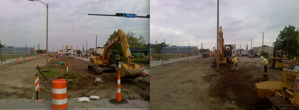
Few people would argue that the 1.3-mile bone-jarring portion of Earhart Boulevard from Jefferson Parish into the Gert Town neighborhood was sorely in need of improvement.
But neighbors in the area have a host of questions over whether the $8.9-million, 16-year-old plan now being executed – suddenly brought to life through last year’s federal stimulus package – reflects either the post-Katina needs of the smaller population or the evolved thinking of urban roadway planning:
- * Are six lanes still necessary where there used to be four?
- * Why aren’t there bike lanes?
- * Shouldn’t we get improved sidewalks and crossings?
- * Where’s the landscaping that would minimize the traffic noise?
- * How safe will it be to cross this wider roadway?
- * Doesn’t this just encourage more and faster traffic?
The Regional Planning Commission, the agency primarily responsible for the project, stands by the plan, even though the underlying traffic studies were conducted in 1997 and the federally required public comment was recorded in 1998.
But the plan by wasn’t designed with neighbors in mind. The “purpose and need statement” provided by the state Department of Transportation and Development says the concerns of business owners were paramount.
“In order to help end the decline and loss of business within the Industrial Park (Tulane-Earhart Business Park) and provide the potential for renewed economic development, the current delays and congestion associated with poor pavement conditions and the inefficiency of signalized intersection must be resolved” the report reads.
The seven-page report, prepared in March 1998, was part of a larger study required by federal regulations. The report cites traffic counts, which are now more than 13 years old.
Jenel Hazlett, president of the Northwest Carrollton Civic Association was struck by the term “Tulane-Earhart Business Park,” used to describe the area where the work is being done – and a term that she had never heard despite her involvement in many post-Katrina planning processes.
The plan outlines the need to “provide improved access between the Tulane-Earhart Business Park and Interstate-10 by increasing travel speeds and reducing delays.”
Hazlett was incredulous reading the report.
“What about the people?” Hazlett asked. “This project is all about the trucks and freight. What about people walking . . . what about bikes?”
Data that would track population shifts and roadway usage since the 2005 flooding of New Orleans are still unavailable, and the Regional Planning Commission is relying on 2000 census data as well as other data sources such as the Greater New Orleans Community Data Center, to estimate the traffic patterns that inform the project, said Jeff Roesel, principal planner at the Regional Planning Commission.
For now, at least, officials have accommodated some concerns of the neighbors, though the project will proceed in a way that will make future expansion as easy as repainting the stripes on the expanded pavement.
The federally mandated environmental assessment for this project was completed in 1998, but the project did not proceed, presumably for lack of funding, Roesel said. It was during that phase that public comment was sought.
“There is no expiration date” on public comment said Doug Hecox of the U.S. Highway Administration, which oversees the funding for this project.
He added that the city had a public meeting on the plan in August of 2004 to determine if this were still a viable project. The minutes of that meeting were not made available as part of the documentation provided to The Lens and prepared for the City of New Orleans, the Louisiana Department of Transportation and Development, or the U.S. Department of Transportation. Area residents have no recollection of the meeting.
Plans for the project show that in addition to the much-needed resurfacing and roadbed reconstruction, the state bought portions of private property to widen the boulevard.
View Earhart Construction Orleans Parish in a larger map
That’s what concerns the neighborhood most, Hazlett said.
“What we see is a very car-centric plan,” she said. “We take pride in being able to walk to our grocery store, and local restaurants.”
Residents drive meetings
Hazlett, who lives two blocks off Earhart, spotted a small ad in the classifieds in May of 2008 that gave notice of the project, prompting her to invite city officials to a neighborhood meeting.
Hazlett said she and her neighbors were shocked to see plans for a wider road, as well as two left turn lanes onto Carrollton Avenue, eating up the grassy neutral ground there.
Hazlett said the Regional Planning Commission was “gracious in listening to our concerns” and responded with a traffic modeling study. That looked at various road and lane options but did not include any hard data on the amount of traffic using Earhart. She said “no one wanted to talk to us about sidewalk plans or bike lanes and greenspace which could act as a sound buffering.”
She contends that the two public-input meetings since 2005 were not instigated by officials, but by the neighbors.
And finding the right people wasn’t easy: “We had to figure out who to talk to, which part was Public Works, which part was Regional Planning, which part was the New Orleans traffic engineer.”
Roesel pointed out that the community-led meetings brought significant changes, such as reducing the travel lanes to two in each direction, striping the intended third lane as a breakdown area. Further, he said, the community concerns over the turn lanes scuttled that part of the plan. Instead, cars will have to do the usual New Orleans left – cross the street, do a U-turn and then turn right.
While Hazlett concedes that the community was able to influence the plan, she feels the process was made more difficult than it needs to be. She said there needs to be more chances for community input and better two-way communication between neighbors and officials.
“Considering that the plans were in the works and on the shelf for more than 10 years before they got dusted off in 2008,” she said she believes that the process could have been smoother.
Neighbors want “complete streets”
Hazlett continues to have concerns about the lack of what planners call “complete streets.” This line of thinking on street redesign takes into consideration all road users, not just cars.
Barbara McCann, the national director of the Complete Streets Coalition, pushes for a broader approach to roadway design.
“A complete-streets policy makes sure that opportunities are not missed to improve the environment for all travelers,” including pedestrians, cyclists and those taking public transportation, she said.
McCann said officials all over the country are rethinking transit planning with “over 130 communities adopting the complete-street policies, including most recently a law passed by the state of Minnesota.”
Hazlett said the Regional Planning Commission seems to have “completely ignored concerns and queries on sidewalks, green space, traffic calming and noise abatement.”
Roesel didn’t respond to requests to explain the lack of bike lanes, sound buffering or landscaping to enhance the area for pedestrians.
Jennifer Ruley a pedestrian-and-bicycle engineer for the Louisiana Public Health Institute notes that Earhart is identified in the city’s master plan as a potential bike route.
She echoes Hazlett’s concerns for not just bike lanes, but added “the use of trees and pedestrian friendly design…can enhance the quality and safety, and improve the community in general.”
Interchanges to nowhere
The Earhart project has a long and storied history. Back in the 1960’s, a plan to connect Earhart Boulevard to Jefferson Parish was developed with the construction of the Earhart Expressway, with the goal of creating a more direct path to the airport.
Funding fell short and so did the expressway, which ends at Dickory Avenue, about 4 miles from the airport. Though the expressway, by definition, has limited access, this one has even less than designed.
The last major improvement to the 4.8-mile Jefferson Parish portion of the roadway was in 1986 with the addition of off-ramps to nowhere and major connecting points unfinished due to a lack of money.
Improvements are coming to the expressway soon, though. Construction of an interchange at Dakin Street is scheduled to start in December. Another interchange at Causeway Boulevard, as well as improvements at Dickory, are in the planning stages.
All of which could invite more traffic to Hazlett’s neighborhood, leaving her concerned that she’ll end up feeling like she “lives on the freeway.”

