
As the state prepares a required five-year update to its long-term Coastal Master Plan, new research has revived three questions that some experts have had for years. The Lens is looking at each question individually this week. Today:
Should the state be planning for the worst-case scenarios of sea level rise and be looking ahead 100 years instead of 50?
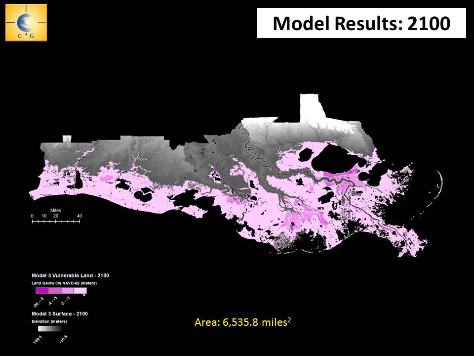
Looking at the latest maps projecting what south Louisiana could look like in the next century could make most residents think of purchasing a boat. A big one.
Because the sediment-starved delta underlying the southeast corner of the state is sinking at the same time seas are rising due to global warming, most projections show the Gulf of Mexico inundating everything outside current levees by 2100. And if nothing is done about greenhouse gasses, some of those projections show the Gulf creeping ever closer to Baton Rouge as the next century progresses.
So why is the state’s last-ditch effort to save its key economic and population center based on a 50-year time frame ending in 2061, rather than meeting the challenges projected to arrive by 2100?
Because, state planners say, those worst-case projections are just that – projections. And the people making them admit they include plenty of uncertainty.
It’s like trying to predict where a hurricane will eventually make landfall the moment it enters the Gulf.
“The further out you go in making projections, the less reliable they are,” said Bren Haase, of the agency’s Planning and Research Division.
“There are so many variables involved here that the confidence level in the results of our models begins to drop off when we get beyond even 10 years. Really, 50 years out is a very long way.
“So when you start talking about 2100, you have very little certainty in the models and projections.”
Sea-level rise projections are a case in point, scientists say.
The main cause of sea-level rise is no longer in doubt, and easy to understand. Water expands when it is heated, and the rising air temperatures caused by greenhouse gas emissions have warmed the oceans causing thermal expansion. At the same time, icefields and glaciers are melting at historic rates due to warmer air, pouring water into the oceans and increasing their volume.
Projections for future sea-level rise typically are divided into scenarios based on forecasts for future greenhouse-gas pollution. Higher pollution results in higher temperatures and faster sea-level rise.
But charts of those predictions look like the long-range forecasts of a hurricane track with a “cone of uncertainty” expanding the further into the future they go. That’s because there remains so much uncertainty about key aspects of the still-evolving sea-level rise science. These include how much the world will do to reduce emissions, how fast the temperature will rise, how fast ice sheets in Antarctica will melt.
Those uncertainties result in wide ranges in the projections.
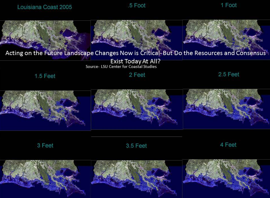
For example, the latest low-emissions scenario for sea level rise by 2100 made by the Intergovernmental Panel on Climate Change, the world’s center for climate research, ranges from 11 to 24 inches, and its high emissions projection runs from 20 to 38.5 inches. In other words, that august body is saying the Gulf could rise less than a foot or more than 3 feet. A very big swing.
And many of the world’s top climatologists think that forecast is too conservative because it does not give enough weight to the melting of glaciers and ice fields.
A survey of the most frequently published researchers on sea level rise produced average low scenarios of 19.5 inches and high scenarios of almost 40 inches.
But even then, 17.5 percent of them actually thought the worst-case scenario would see as much as 6.5 feet of sea level by 2100 – 3 feet higher than the IPCC worst-case estimate. And that projection is shared by the National Oceanic and Atmospheric Administration.
On the other hand, a recently published study indicates warming may actually lead to slowing the rate of sea level rise as drought-parched continents act like sponges soaking up rainfall, reducing the runoff into oceans.
So if you’re a coastal agency working with a budget of not more than $50 billion in 2010 dollars, which forecasts do you choose to guide your goals? Do you select the longer-range worst-case scenario that is projected less likely to happen, or do you stick with the more certain short-range forecast?
Either choice is a gamble with serious consequences.
Opting for the more reliable short-term forecasts could turn out to be a waste of money – and futures – shortly after the plan’s 2061 completion date if sea level accelerates at the rates forecast in the worst scenarios. And at that point, the state would have little money left to begin implement any other plan.
Choosing the long-range, worst-case scenario for sea level rise and subsidence would require abandoning most of the lower coast the current master plan aims to protect and save. Communities would be required to relocate generally north of U.S. Highway 90.
But what if you embarked on that decades-long, painful and expensive process, moving families and industries, only to see the world finally reduce emissions and the rosiest, best-case scenarios of just 11 inches by 2100 turn out to accurate?
Those questions were considered by the some of the world’s top coastal engineers and scientists recently in the Changing Course Design Competition. Co-sponsored by Louisiana, the competition asked international teams to design the best way to have a sustainable coast into the next century considering the science available.
Facing no restraints on costs and no requirements for social or political approval, the three winning entries concluded the state should plan for something close to the worst-case sea level rise scenarios.
They agreed the mouth of the river should be moved north at least 40 miles in order to maximize capture of the river’s sediment, and thes state should begin engineering and maintaining smaller delta habitats much closer to New Orleans.
Each thought the lower section of the coast should be slowly abandoned over the next 80 years because it would be unsustainable due to the latest projections of the rising Gulf and sinking land.
Jeff Carney, director of the LSU Coastal Sustainability Studio, was a member of one team. He said there was little disagreement on accepting the worst-case scenario for rising seas and sinking land. Looking at the research on sea-level rise and the geology of the delta landscape, U.S. 90 was roughly the fallback line for what part of the coastal zone could be fortified and sustained into the next century.
“This is going to happen,” he said. “So the choice is, do we get out in front of it over the next 50 years and manage the process [of retreating], or wait for it to happen to us – wait for the next big storm to wipe out communities, erase the shipping channel in the lower river and throw commerce into chaos?”
Harry Roberts, the noted LSU researcher who also served on a winning team, acknowledged the advantage they had being absolved from political approval.
“The current philosophy is pecking around the edges of the problem with these small diversion in their locations so we don’t get anybody mad,” he said. “But, eventually, that will have to change.
“The question is how do we get the best bang for the buck, and how do we get something we can sustain into the next century. In our mind that means bigger diversions and further north.
“That’s what the projections show.”
But will those long range projections be accurate?
Tomorrow: Is it worth investing $92 billion in wetlands that might be gone 40 years later?
This story is the third part of a series looking at questions facing state officials as they update the Coastal Master Plan. The first story is here, with links to the rest at the bottom of that story.

