Since 2007, Louisiana coastal experts have claimed they can prevent the state’s bottom third from sinking into the Gulf of Mexico based on this assertion: The Mississippi River carries enough sand and sediment not just to repair some of the damage but actually begin rebuilding wetlands.
Now they finally may have the research to prove it.
Preliminary findings from the first comprehensive study in more than 50 years on the amount of material the river hauls south of New Orleans appear to support the land-building conclusions in the 2012 Master Plan, researchers said in several recent interviews.
Among the key findings from the continuing Louisiana Coastal Area Hydrodynamic and Delta Management Study:
- Enough sand and sediment move through the river to meet the land-building projections for sediment diversions and dredge-and-fill projects in the 2012 plan.
- The proposed sites for sediment diversions are in the right locations to achieve the projected results.
- Sediment loads in the river have stabilized over the past two decades after steady declines.
- Deposits of sediment at critical locations are deep enough to supply dredge-and-fill marsh-building projects.
- Effects expected from climate change and coastal subsidence will not prevent the river from delivering enough material for the projects to meet goals.
Bren Haase, heading the project for the state Coastal Protection and Restoration Authority, said while those findings are encouraging, more data collection and analysis are needed to refine conclusions of what the river carries and how to effectively capture it for rebuilding wetlands.
“Sediment is flowing down river continuously as if it were on a conveyor belt,” he said. “Our focus is on finding strategies like sediment diversions and dredging to efficiently harvest that sediment as it goes by on the conveyor belt.”
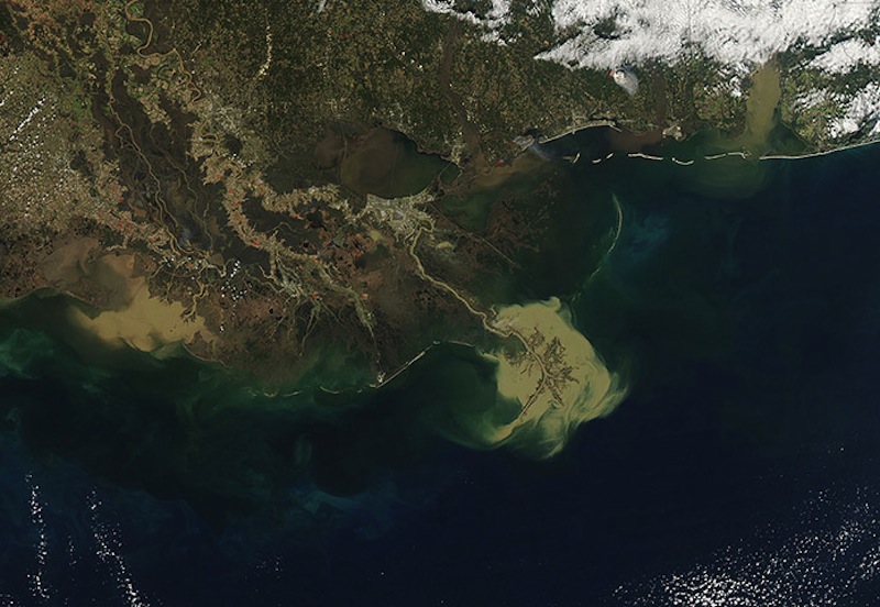
All of south Louisiana rests on deltas built by the Mississippi River. But almost 2,000 square miles of its coastal landscape has converted to open water in the last 80 years due to river levees that have starved the deltas of sediment, as well as erosion caused by thousands of miles of canals dredged for oil, gas and shipping. The National Oceanic and Atmospheric Administration has projected at current rates of subsidence and sea level rise, the entire southeast corner of the state will be part of the Gulf by the end of the century.
“The surprising thing is, it looks like it’s stabilized at a level not seen since European settlement came to the river,” based on soil borings. —Bren Haase, Coastal Protection and Restoration Authority
The 2012 Master Plan drew national attention and buoyed the spirits of coastal advocates with the claim the state could be gaining more land than it was losing if its $50 billion suite of projects was implemented by 2060. But skeptics of the plan quickly pointed out some of the information used in those models dated from the 1960s.
Current data would have been available had Congress funded a study it authorized in 2004. But the money didn’t come until 2011.
Since then, the Army Corps of Engineers has partnered with the coastal authority on the $25 million research effort, which includes projecting the effect projects would have on their receiving basins.
Past studies had shown sediment load dropping steadily over the past few decades as farming conservation methods have reduced soil runoff into the Mississippi River drainage. But Hasse said the new study shows the river is back to a form not seen in centuries.
“We hear a lot of talk about sediment load in the river but found that sediment loads have stabilized in the lower river since those declines,” Haase said. “The surprising thing is, it looks like it’s stabilized at a level not seen since European settlement came to the river,” based on soil borings.
The river also appears to carry enough water to move large enough loads of sand and sediment needed to rebuild the sinking basins south of New Orleans. That became a concern after 2011 research found the Mississippi loses 54 percent of its volume between the Old River Control Structure north of Baton Rouge and its mouth at the Gulf of Mexico.
“The water volume flow down the river has been stable since about 2000 and is projected to remain stable,” said Ehab Meselhe of The Water Institute of the Gulf, which is working for the coastal authority on the research.
“We’re encouraged but we still have a lot of questions that have to be answered.” — Ehab Meselhe, The Water Institute of the Gulf
Meselhe said those results included running numerous scenarios for subsidence, as well as various levels of sea level rise and rainfall projected by climate change models.
And the researchers said nature provided unexpected help with the 2011 river flood. The Bonnet Carre Spillway opening provided a real-world test for the accuracy of the models being used to predict the effects withdrawing large volumes of water from the river will have on shipping as well as sediment transport.
“We did model periods right before, during and right after the flood and a couple years after the flood, and that gave us a lot of confidence this model can give us reliable information on how diversion openings might impact the river,” Hasse said.
But they still have plenty of work to do, he said.
“We’re encouraged but we still have a lot of questions that have to be answered,” he said.
Even those answers might not be the final approval for sediment diversions. Kyle Graham, head of the coastal authority, has said the agency was still determining a cost-benefit analysis for the diversions.
The key question: Will the projected benefits in storm surge reduction and fisheries production gained by wetlands restoration outweigh the costs in construction and operation of the diversions, any possible added flood risk to surrounding communities, as well as any disruption to current fishing industries.
Some fishing groups oppose the diversions because they are concerned reduction in salinity levels caused by the river water could displace their target species.
Graham said the first decision of that kind likely will come this fall when research is final on the impacts of the planned Myrtle Grove diversion in Plaquemines Parish.
