Credit: NASA
The Changing Course design competition is picking the world's best brains for ideas on solving Louisiana's coastal challenges. Eight teams have advanced to the semifinal round.
The Changing Course design competition is picking the world’s best brains for ideas on solving Louisiana’s coastal challenges. Eight teams have advanced to the semifinal round. Credit: NASA

If you’re developing one of the largest river management projects in the world — an initiative with social, economic and political challenges — where do you look for help?

Well, everywhere.

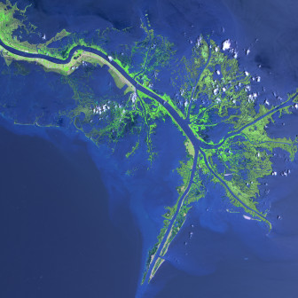
That’s the idea behind the Changing Course competition – a call made to the world in September from Louisiana offering $400,000 for ideas about how to maximize the Mississippi River’s ability to rebuild the wetlands south of New Orleans, while also meeting “the needs of navigation, flood protection and coastal industries and communities.”

Twenty-one teams with members from 23 states and seven countries responded by November. That group has now been pared to a semifinal group of eight.

By April, two to four teams will receive funding to fully develop ideas that could be included in the 2017 version of the state’s Master Plan for the Coast.

So why is Louisiana looking for ideas when it already has a 50-year, $50 billion blueprint to achieve the same goals as those outlined in the competition?

Steve Cochran of the Environmental Defense Fund, which is helping manage the process, says the answer is simple: Picking the best brains in the world is never a bad idea.

“The competition isn’t saying the ideas in the plan aren’t good ones,” he said. “These competitions are used when you have a project of this significance because everyone agrees, the more eyes you have on a challenge, the better the result.”

The goal is to spur ideas that have “the engineering and design quality” as well as the involvement of stakeholders, such as the shipping and fishing industries and coastal residents.

The competition is a public-private effort developed by a 17-member leadership team that includes representatives from the state, the U.S. Army Corps of Engineers, university and private sector researchers, and stakeholder groups.

“Other parts of the world are facing the same problems we’re challenged with here – including sea level rise – so we’re hoping this exercise will also showcase the expertise we have on addressing those problems.”—Steve Cochran, Environmental Defense Fund

The applications and designs are being reviewed by a 12-member technical team, which is working with the leadership team.

The competitors will have access to technical data already collected by the state and the corps, and they can consult with a stakeholder team.

Cochran said the leadership team has not been surprised by the enthusiastic interest from some of the world’s top engineering firms. Louisiana’s problems on its southeast coast are similar to those being experienced on deltas across the planet.

“Part of the attraction was that in this case, Louisiana is ahead of the rest of the world with the Master Plan,” he said. “If this is the sort of work they do, then this is where they want to be. They want to be part of this design initiative to demonstrate their capacity to think about solving these kinds of problems, which will be an advantage in competitions going forward.”

Cochran said organizers hope the competition will provide a boost for the state’s technology industry.

“Other parts of the world are facing the same problems we’re challenged with here – including sea-level rise – so we’re hoping this exercise will also showcase the expertise we have on addressing those problems,” he said. “By showing the world what we can do — by making plans concrete, we’ll be able to market that expertise and have an economic payback in the future.”

Entering the competition involves financial risk because the teams must bear all the costs of their proposals. Only the finalists receive a part of the $400,000 to develop their ideas.

Cochran said funding comes from the Rockefeller Foundation, Blue Moon Fund, the Kresge Foundation and the Selley Foundation, which is administered by the Greater New Orleans Foundation.*

Teams advancing to semifinal round

*Correction: This post originally stated that one of the funders of the competition was the Rockefeller Family Fund, but it’s the Rockefeller Foundation. It also omitted the Kresge Foundation. (Dec. 12, 2013)

From 2013 to 2017, Bob Marshall covered environmental issues for The Lens, with a special focus on coastal restoration and wetlands. While at The Times-Picayune, his work chronicling the people, stories...

8 replies on “Changing Course design competition picks world’s best brains on how to restore Louisiana coast”

  1. With sea-level rising as fast as it is, a new channel to abandon the existing delta is needed that let’s it go back into the sea, stepping back for a new shoreline at least 2m/6.6ft higher, plus spring tides and hurricane surges, that’s going to be your new world for a short while.

    I personally don’t think it’ll matter what we do as the accelerated sea-level rise is exponential without going to zero greenhouse emissions as the goal, a fast transition to drop CO2 radically as far as can be done knowing it will rebound.

    Without that you build to 2m then the next century it’s well over that and Miami is history. What’s the plan?

  2. I think you just said it. It’s a plan called retreat and return – retreat from the coast and return it to nature. Robert Young at Western Carolina University is one of the primary spokesmen for the movement.

  3. Thanks Chris, will check into Young’s work, my comment was more a reaction being into geomorphology & hydrology than anything else. A difficulty always with the delta & river are the modifications to the channel upstream. Along with the sea-level is the possibility of intense flooding events to compound designing a solution, assume Young & others are aware of it all.

    Another facet of the problem is that in Antarctica some ice-streams appear to be accelerating and they don’t respond to climate and can add to sea-level significantly because this is all plateau ice. This appears to happen every 7,000-years or so from the weight and volume finally reaching a point where the ice-streams begin to flow from a melted base with enough weight to lift the ice-stream so it flows quite fast for hardly any gradient.

    Perhaps not on the public radar, it’s now being factored into the models.

  4. I agree with you that the anthropogenic effects of climate
    change have the potential to cause an accelerated rate of sea level rise, but
    that is also an overprint on natural sea level rise. Global sea levels have risen by more than 400

  5. How much has sea level risen along the Louisiana coast? Since it is rising so fast, the inchesof elevation of Louisiana marsh should have already been submerged! Scary stuff!

  6. Well the reason the IPCC 2007 sea-level rate of rise was under is because it didn’t include the dynamic effect and today it’s rising at an exponential rate so that’s a reality, not a potential.

    Not a big deal now it’s in recent models but at 400-ppm the stimulus is for 82ft/25m more sea-level the latest estimates range from 300-500 years, the peak value of CO2 for the previous interglacial was about 287-ppm and sea-level went 3m higher than today when it balanced out.

    The long-term message is 25m of rise and it can’t be stopped if we go to zero emissions today, that’s reality.

    We have to dump CO2 down to 280-ppm again or kiss off Holocene atmospheric circulations, we already lost the balance and have pushed feedbacks now starting into what I’ll call “hyper-heating” contrasted to natural systems having jumped CO2 43% in 200-years, a spike, a huge disrupting change we’d be roasting from without an ocean heat sink but it’s warming fast and that’s sea-level rise a feedback.

    So, to me it’s beyond fixing without radically dropping CO2 faster that it was raised in the hope the planet’s systems didn’t get moved too far and begin a cooling trend and the sea-ice begins to return in the Arctic, that’s the indicator, that’s the thermometer of the planet to watch.

    Either way it’s storm by storm that will wipe out things that won’t get replaced or rebuilt back to normal before the next one hits, it’s not so much the absolute value of the rise, it’s the volume of a surge grows much larger, amplifying what to most people think is trivial.

    This needs to be visualized. We’re close to 3mm/year rise but it doesn’t go up in a nice tidy straight line, it jumps up & down about a foot to slowly rise as an average value.

    So the area of the sea affected can have an extra 6″ during a storm, Sandy had 4-6″ more when it hit and that did make a difference there by adding to the natural amplification from the shape of the coast, a long known problem.

    Getting that message that the process isn’t linear and the risks are much higher from amplification than risk assessments show without that factor is hard, I can barely explain it to friends. So I agree with you we need to hit leaders with this and other messages, it’s a big issue.

  7. http://www.scribd.com/doc/191575449/Roberts-on-SLR
    These are two pages from the work of Harry Roberts and Micheal Blum. The first shows teh same Grand Isle tidal data graph that Tim showed, but with a relationship to the Global Mean Sea Level Change. As Tim has said, this graph does not reflect any of the recent revelations about the potential for an exponential rate of increase. The difference between Grand Isle and the Global rate is interpreted to be due to subsidence (hence a relative sea level rise). On second page Roberts takes into account the lack of sediment being delivered by the Mississippi River, and shows a projected shoreline for the end of the century (also not reflective of the exponential rate of increase.

Comments are closed.