
An engineer has advised the local Flood Protection Authority that the area’s protection against storm surge may not be as robust as the U.S. Army Corps of Engineers claims because of large gaps in the data the agency used for the system’s specifications.
Most of the gauges in coastal Louisiana, from the Gulf to Lake Pontchartrain, aren’t built to withstand storm conditions, so they don’t have the detailed data that can be plugged into a computer model.
“We really don’t have enough information to improve our estimates of surge risk.”—Bob Jacobsen, coastal hydrologist
Gathering that detailed, local data would require installation of gauges that can withstand storm conditions and report back in real-time — but the agency doesn’t have the money to buy them.
Bob Jacobsen, a coastal hydrologist hired by the Southeast Louisiana Flood Protection Authority-East, said the corps’ estimates for storm surge risk and the overtopping of levees is based on data with a large degree of uncertainty.
“We really don’t have enough information to improve our estimates of surge risk,” Jacobsen told the operations committee at a September meeting.
According to Jacobsen, data on how waves behave when they come on shore or roll over levees is necessary to accurately estimate overtopping rates of levees and floodwalls. Because such data is scarce for this region, the corps used estimates from other areas, including the Netherlands and California, to build the local defenses.
“Lake Pontchartrain and Lake Borgne are a lot different than the North Sea and the Pacific Ocean,” Jacobson said. “You are talking about bodies of water that are much shallower, and the wave characteristics are much different.”
In an interview with The Lens, Jacobsen stressed that the public should not panic due to the belief that levees and floodwalls are not high enough. However, additional data is necessary to boost the quality of the corps’ estimates.
During Hurricane Isaac, 16 of the 25 corps’ gauges in the three outfall canals and the entrance to Bayou St. John went out or gave false readings at some point. The Sewerage & Water Board of New Orleans and the corps use those gauges to coordinate how fast rainwater can be pumped into the canals.
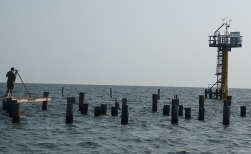
Gathering the necessary data would require a series of gauges that could be deployed as a storm approaches, as well as “hardened” sentinel stations, which are permanent structures located in open bodies of water designed to collect data throughout the life of a storm.
Unlike gauges used to collect wave data, sentinel stations collect real-time information on stillwater levels, current, wind and air pressure, all of which are key to modeling storms and estimating storm surge risk, Jacobsen said. There are a handful of these stations already in the Gulf, but Jacobsen argued that at least a dozen more are needed, in every water basin in the area.
4Hardened gauges off Mississippi and Louisiana coasts2Hardened gauges off Texas coast
“We have large areas of coastal Louisiana with little to no coastal monitoring by these types of stations,” said Tim Osborn, a scientist at the National Oceanic and Atmospheric Administration, in an email.
“This makes the protection of coastal parish residents, businesses and infrastructure very challenging,” he said, and hinders agencies from having “a year-round understanding of storm events and water level and coastal flooding events that may impact a specific area.”
NOAA has installed four sentinel stations in Mississippi and Louisiana: at Calcasieu Pass near the Texas border, Amerada Pass in Atchafalaya Bay, and Shell Beach, and Bay St. Louis.
In 2011, Texas A&M University’s Conrad Blucher Institute for Surveying and Science installed two sentinel stations along the Texas coast. The two steel structures cost $380,000, plus another $120,000 to buy and install the monitoring equipment. It costs $20,000 to $25,000 a year to operate and maintain them, said James Rizzo of the Texas Coastal Ocean Observation Network.
This year, the institute got $2 million for four more.
Stephen Estopinal, treasurer of the Flood Protection Authority, said those price tags are beyond the reach of the agency.
According to Estopinal, the authority’s budget is already allocated for other projects, including its share of the new $14.5 billion storm surge protection system being built by the corps.
“We don’t have a lot of money to throw around. We have a lot of things we have to do inside the protection area that we are really concerned about,” Estopinal said.
Estopinal said that the agency probably would have to get money for that equipment from grants or partnerships with private entities, not the government.
Adding to the financial pressure, the levee board disclosed Thursday that the state Coastal Protection and Restoration Agency had decided not to issue $500,000 in funding previously authorized by the Legislature.

