
Consider this: It’s spring 2025 and Louisiana officials are preparing to open three diversions on the lower Mississippi River so fresh water and sediment can reach wetlands struggling to stay ahead of sea level rise.
But the river has dropped to a record low, and the Port of New Orleans warns that taking so much water from the river will ground ships downstream of Venice.
At the same time, salty Gulf water moving upstream against the low river threatens municipal water supplies, as well as cooling intakes at oil refineries, chemical plants and power stations. They want the diversions to stay shut.
Meanwhile, all three uses of the river could be disrupted when Arkansas opens a structure on the river to send millions of gallons of water to western states willing to pay top dollar to relieve a drought devastating farms and cities.
So, who makes the call on what is the most important use of the river water?
If that happened today, no one.
“Right now, there is no one authorized to make that call,” said Mark Davis, Director of the Institute on Water Resources Law and Policy at Tulane University. “Nobody has been told, ‘You’re the referee on using this river.’”
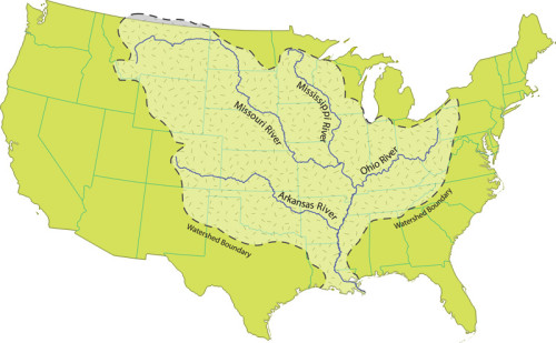
It turns out the Mississippi River, with a watershed critical to the economic life of 31 states, has no single working water budget, but instead is tapped on a first-come basis.
While some rivers, most notably the Colorado, have long been subject to legal agreements parceling out water to its users, the Mississippi has been left to a laissez-faire style of management: Each state takes what it wants as the river flows inside its borders.
That lack of oversight, long an economic concern for southeast Louisiana, is growing into a mortal fear due to this scientific consensus: The region’s only hope of staying above the 4.3 feet of sea level rise expected by century’s end is to get the river’s fresh water and sediment back into the region’s sinking marshes.
That means the river’s water and sediment are now considered life-saving resources. And having 30 different, self-interested management plans preceding Louisiana’s needs could be a prescription for disaster, coastal scientists say.
“We’ve been living with a management system for the river developed in the 1930s, and that’s not the world the river has to serve today,” said Paul Kemp, a geologist and coastal researcher at Louisiana State University. “There are many more users, and different users than we had in the 1930s.
“And I think recent events are helping convince more people we need a new type of management for the river.”
One river, many uses
Two of those events are the mounting impacts of climate change and Louisiana’s Coastal Master Plan.
As predicted by climate scientists, global warming is now bringing stubborn droughts to the Great Plains states and wild weather swings to the half of the country drained by the Mississippi River.
A historic Mississippi flood in 2011 was followed by a historic drought in 2012. Industrial plants went from sandbagging property to closing down because the river was too shallow to ship their goods. By the end of last summer, calls rose in Mississippi River states for a management plan to help users prepare for and reduce the cost of those extremes.
Meanwhile, a lingering drought has southwestern states talking again about tapping the Mississippi.
On the southern end of the river, Louisiana’s 2012 Coastal Master Plan would pour those resources into sinking wetlands basins with as many as nine diversions, some of which could move as much as 250,000 cubic feet of water each second.
Those plans worry many other users even though they, too, need the coast restored to prosper.
The Port of South Louisiana, which includes New Orleans and Baton Rouge, is the nation’s largest, a vital economic driver for many states upstream. Shipping interests that rely on the port want assurances that diversions will leave enough water in the river to float their vessels.
Communities and industries that rely on the river’s fresh water need to know that they’ll have water to supply their drinking water and cool their machinery.
The fishing industry needs to know how and when its prey will be affected by those new waves of fresh water moving through the basins.
But the river that offers the coast new life also poses problems. For decades, the way that northern farms have used the river has harmed Louisiana.
Dams built on the Missouri River for irrigation and power blocked about 40 percent of the sediment load that had been building southeast Louisiana when Europeans arrived. As a result, the state now has less time to save the coast; the pace of subsidence and sea level rise soon will make the problem too large and deep for the available supply of raw material.
Meanwhile, the nitrates, phosphates and other pollutants from crop fertilizers and livestock runoff drive the dead zone that extends thousands of square miles along the coast, posing a threat to the seafood industry. And recent research shows that those same river-borne pollutants can cause marshes to collapse, adding to the state’s coastal erosion.
So changing how states to the north use the river, and how much of it they use, is important to Louisiana’s future.
How to “spend” the river water
The budget concept evolving among Louisiana’s coastal policy experts doesn’t resemble a budget most people would recognize, such as prioritizing spending based on available assets.
“That,” Kemp said, “is an outmoded way of thinking about river use.”
Instead, scientists and policy experts stress a different approach.
“We have to move beyond who gets first call, and look at the river as one system that has many needs,” said Kemp. “There are ways to make these different uses not just compatible, but complementary.”
For example, the U.S. Army Corps of Engineers has three missions on the river: maintaining navigation, providing flood control and, most recently, restoring the ecosystem. Rather than parcel out how much water goes to each purpose, Kemp said, they could complement one other.
“When the river presents a flood threat we can open the diversions, lessening the flood threat by removing water while we’re building wetlands at the same time,” he said. “And when the corps needs to dredge to keep the shipping lanes open, it can dispose of that material in a way that helps rebuild wetlands.”
Louisiana coastal advocates also say that states along the Mississippi have to stop looking at the river as a local resource and begin viewing it as an organism that can’t fully serve any state if its coastal end isn’t healthy.
[module align=”left” width=”half” type=”pull-quote”]“We have to move beyond who gets first call, and look at the river as one system that has many needs. … There are ways to make these different uses not just compatible, but complementary.” —Paul Kemp, coastal researcher and geologist[/module]
For instance, if Louisiana doesn’t have the river material to rebuild its southeast coast and protect the Port of South Louisiana from frequent closings, every state upstream is hurt as well, Davis said.
“If you don’t have a river that works for navigation in the long-term, I don’t think you have a river that works for the farmers and the other [industries] that need the river to ship their goods to the world,” Davis said. “And if the river isn’t working for those states to send their goods south, you don’t have a river that works for New Orleans and other communities in this region whose economies depend on a healthy port.
“Similarly, if you don’t have a river that essentially helps sustain communities and keeps them reasonably protected from floods, then you don’t have a river that works.”
Louisiana’s working-together theme is also grounded in political reality, Davis said. There’s no chance that the dams on the Missouri will be torn down to increase the sediment supply to Louisiana. Or that the powerful, multi-state farm lobby would support tough regulations on fertilizer use and livestock operations.
“But we can show that the economics of fertilizer use say if it’s in the river, somebody is paying for something they didn’t need,” said Davis. “So I think there has to be an approach to the use and management of fertilizers that keeps it on the field, where it’s intended to be.”
Developing this management plan for the river should be an urgent priority for Louisiana and the entire Mississippi River drainage, Davis said, because it will be essential to saving the state’s coast and ports.
Any management plan for the river will have to be based on the “needs of this coast and everything it serves,” he said.
“And that is based on the realization if you do not have a functioning mouth and delta on this river, you do not have a functioning river.”

