
On Thursday, Gov. John Bel Edwards grabbed a hard hat and shovel and walked towards a pile of dirt brought here thousands of years ago by the Mississippi River.
A few minutes later, 16 pristine shovels dug into the dirt and the cameras flashed, officially breaking ground for the Mid-Barataria Sediment Diversion.
Soon, crews in Plaquemines Parish will begin five years of construction, to create the diversion, the state’s most ambitious wetlands restoration project. If it works as planned, the river will unload more of its sediment and nutrients here, to build up this rapidly eroding part of the state’s coast.
Once completed, the project will allow a controlled diversion of water and sediment from the Mississippi River to the Barataria Basin, a bay of the Gulf of Mexico.
A new man-made channel that will bring river water to the basin
The $2.9 billion project is at the heart of Louisiana’s 2023 Coastal Master Plan. The idea is to recreate the river’s natural marsh-building process in Jefferson and Plaquemines parishes.
Part of the river will once again travel through those marshes, thanks to a gated structure that will be built into the west bank of the Mississippi River levee near Ironton. The gates will be opened strategically, at times of high river flow, to divert water from the river into a new, man-made channel that will guide the water for two miles – under two new bridges, built for a railroad and Louisiana Highway 23 – and ultimately to the bay.
Sediment and nutrients left along the new two-mile distributary ridge, experts say, can rebuild between 20 and 40 square miles of wetland habitat over 50 years, depending on the rate of future sea level rise.
“We’re addressing our coastal crisis at its fundamental core,” said Bren Haase, chairman of the Coastal Protection and Restoration Authority board, which is charged with developing, implementing and enforcing the Coastal Master Plan.
For thousands of years, this section of the river delta area was built up by sand, silt and clay, deposited by the mighty Mississippi into the waters of the northern Gulf of Mexico. That natural process was disturbed in the 1930s when marshes were cut off from the river, and its sediment, by the levee system, built along the river to protect residents and infrastructure from flooding.
Since then, approximately 1,900 square miles of Louisiana has receded into open water, because of two major threats – subsidence and sea-level rise – made worse by human strong-holding of the river. Before the arrival of the highly engineered levee system, the river naturally flooded the delta with land-building sediment.
Last week’s groundbreaking marks an effort to reverse that land loss.
“The historic importance of beginning construction on the Mid-Barataria Sediment Diversion cannot be overstated,” said Simone Maloz, campaign director of Restore the Mississippi River Delta. “This project is a visionary effort that positions Louisiana as a global leader, using the power of nature itself to create more wetlands than any other single restoration project in the nation.”
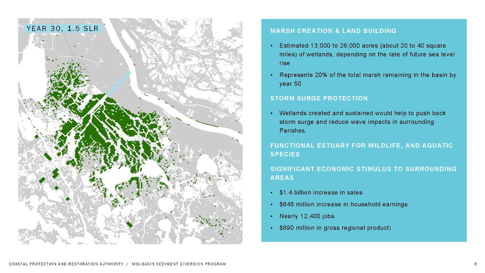
A graphic shows the potential wetland restoration that could be rebuilt over the next few decades. The project is expected to be completed in about five years (Coastal Protection and Restoration Authority).
‘The river is what’s going to save us’
“Today will be remembered as a critical turning point for Louisiana’s coast,” said Gov. Edwards, noting that since 2016, when he took office, roughly 26,000 acres of coastal land have been rebuilt, thanks to the coastal master plan and its bipartisan support. “If you maximize the role of science, you minimize the role of politics,” he said.
The Mid-Barataria Diversion Project, the largest ecosystem-restoration project in the state’s history, Edwards said, shifts land-building into high gear, to the point where the land created could outweigh the amount being lost.
“The river is what built Louisiana and the river is what’s going to save us,” said U.S. Rep. Garret Graves, a former head of the CPRA, who helped to forge agreements after the 2010 British Petroleum spill. Nearly 134 million gallons of oil flowed into the Gulf, for 87 days, causing losses that can still be felt in the coastal ecosystem, including a 51% drop in the dolphin population in the Barataria Bay and the die-off of an estimated 8.3 billion oysters.
The diversion is funded by the Deepwater Horizon oil spill settlement, a $20.8 billion penalty meant to offset environmental damage caused by the oil-rig explosion.
The land-loss reversals can’t come fast enough for State Sen. Patrick Connick, who said that the fishing families within his district need the Barataria marsh, which has been in danger of disappearing altogether. That could reverberate nationally, since one-third of seafood consumed nationally comes from Louisiana, Connick said. “Without our fishing industry, the Louisiana economy suffers and so does our country.”.
However, not all oyster growers, shrimpers and other fishers are happy about the diversion – which will alter the coastal ecology.
For instance, oysters and brown shrimp rely on the brackish waters of the Barataria Basin, which will become more fresh water as the diversion project increases the flow of river water into the bay.
To address this, the project includes a $378 million set-aside, to mitigate expected damage to oyster beds and fisheries.

An example of land-building along a nearby section of shoreline
This part of the coast had been open water only three years ago.
Last week, after the groundbreaking, Bren Haase of CPRA drove further downriver and got on a boat for a ride through what could be described as some of Louisiana’s newest wetlands.
“I don’t know how else to describe this place other than alive,” said Haase, as he gave a tour to journalists of Quarantine Bay, which is located near the mouth of the river across from Buras.
In recent years, within the river’s ever-changing delta, a small channel known as Neptune Pass had begun to widen naturally, bringing more river water into Quarantine Bay. Along with the increased water came sediment, which has built up sandbars and land here in this part of the coast.
The hope is that, in several years, Barataria Bay will see similar ecological changes.
“We’re just watching this area be born again,” said the boat’s captain, Ryan Lambert, owner of Cajun Fishing Adventures, as he pointed to the new land stretching for miles on either side of the pass. Already, the land is habitat for grasses, birds and trees.
The new vegetation may also have an effect on the size of the Gulf’s Dead Zone.
The sediment that settles in Quarantine Bay carries nutrients from agricultural runoff that would have otherwise caused low oxygen levels here, where the river empties into the Gulf.
Instead, when paired with the sediment in the bay, the nutrients have helped spur the return and growth of plants along the new land, including delta duck-potato, pampas grass, cordgrass, cypress trees and willow trees.
The new growth has given Lambert high hopes for the new diversion that just broke ground upriver. “I can’t wait to see Mid-Barataria and what it’s going to do,” he said.
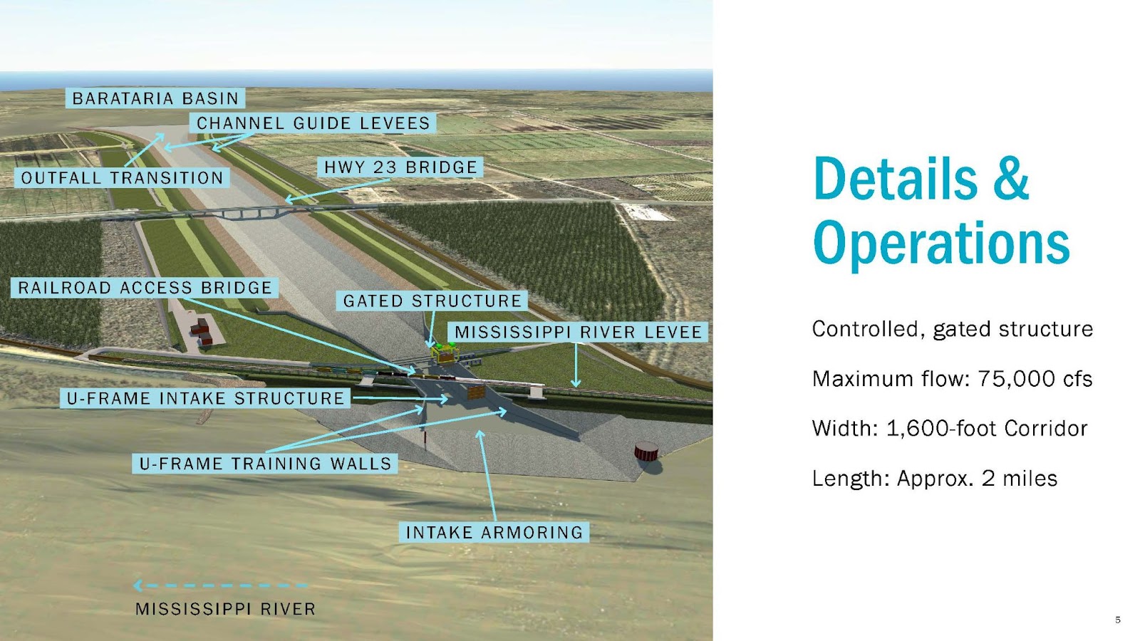
An artist’s rendering of the Mid-Barataria Sediment Diversion project shows the controlled, gated structure that will be opened when the flow of the Mississippi River is high and carrying land-building sediment (Coastal Protection and Restoration Authority).

