The Washington Post has confirmed what you probably knew already: Nights in New Orleans have been sweltering.
This year, there have been 43 nights when the temperature never dropped below 80 degrees – smashing the previous mark of 13 set in 2010, according to state climatologist Barry Keim.

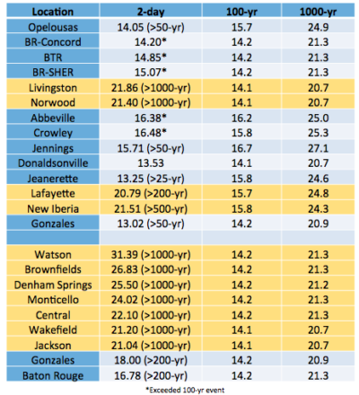
Keim, the source for the story, has been talking about this trend quite a bit. He told The Lens that it probably contributed to the horrific rainstorms in August that dumped more water than a 1,000-year event in nine Louisiana communities.
As air warms, it expands. That, in turn, increases the amount of water vapor it can hold – and how much can be released in the form of rain.
Keim said the dew point this summer — that’s the temperature at which moisture in the air condenses to form dew — has been 6 to 7 degrees above the norm. Each one-degree increase in the dew point increases the moisture content of the atmosphere by 4 to 5 percent, he said.
“The higher the dew point, the more moisture the air can hold, and typically in summer nights the dew point in New Orleans is about 73 to 76 degrees – which is why it can feel so sticky when you wake up,” he said.
“But the last few years we’ve been seeing more and more in the upper 70s, and up to 80,” he said. “A few years ago, one [dew point] was 83, and this summer we’ve been around 80 quite a bit – which is sort of obscene and off the charts.”
In a Facebook post, Keim pointed out this is part of a long-term warming trend. From 1946 to 1976, there were just six nights in which the temperature didn’t drop below 80 degrees. Since then there have been 145. Almost 30 percent of these hot nights have occurred in the past few months.
On a daily basis, this is why your shirt sticks to you as soon as you walk outside. It also means there’s more moisture waiting to be unleashed in an unusual weather system like the one that caused the flooding in Baton Rouge, Denham Springs and other communities.

