
The Mississippi River is mighty big. So what else is new? How about this: For all the effort to line the river’s banks with levees and shunt the continent’s biggest drainpipe to the Gulf of Mexico, as much as 5 to 10 percent of the water goes missing before it ever gets there.
That’s the conclusion of geologist Alex Kolker, an assistant professor at Louisiana Universities Marine Consortium and an adjunct professor at Tulane University.
The missing water all by itself would constitute the fourth largest river in America — far bigger than, for example, the Hudson River, Kolker said.
He’s not talking about the water that gets siphoned into corn belt irrigation projects or breweries at St. Louis. His focus is water that’s presumed to be in the river channel near New Orleans — but isn’t.
Kolker picked up on a clue to the mystery while swimming in Barataria Bay during a research trip six years ago: “It seemed less salty than one would expect.”
Intrigued, Kolker and research associates began measuring water levels, salinity and radon in the bay and at points upstream. Their conclusion: Vast underground bayous are stealing water from the river’s main channel and releasing it at scattered sites across the entire delta.
The team measured radon to determine whether the fresher-than-expected water in Barataria Bay was from rainwater and leaky pipes or, as Kolker suspected, from groundwater.
“Because radon concentrations in groundwater greatly exceed those of surface waters, it can be used to quantify groundwater inputs if all other radon sources and sinks are budgeted,” Kolker writes in an article co-authored by research scientists Jaye Cable, Karen Johannesson, Mead Allison and Lorna Inniss and just published in the Journal of Hydrology.
Yes, their analysis showed that the bay water was coming from the river, but that led to another question: How was it getting there?
Using sonar, the team found evidence that the water may be traveling through old bayous, some of them prehistoric, others visible on early geological maps but buried now and wrongly presumed to be inactive.
They write in their research paper:
These abandoned river channels were typically sandy beds, which formed either slow-moving bodies of water, locally known as bayous, or were subsequently buried forming paleochannels. … As bayous aged and filled in with organic material and fine-grained sediments, the buried sand deposits of their banks and bottoms became available as conduits for river water to enter the coastal ocean through subterranean flow paths.
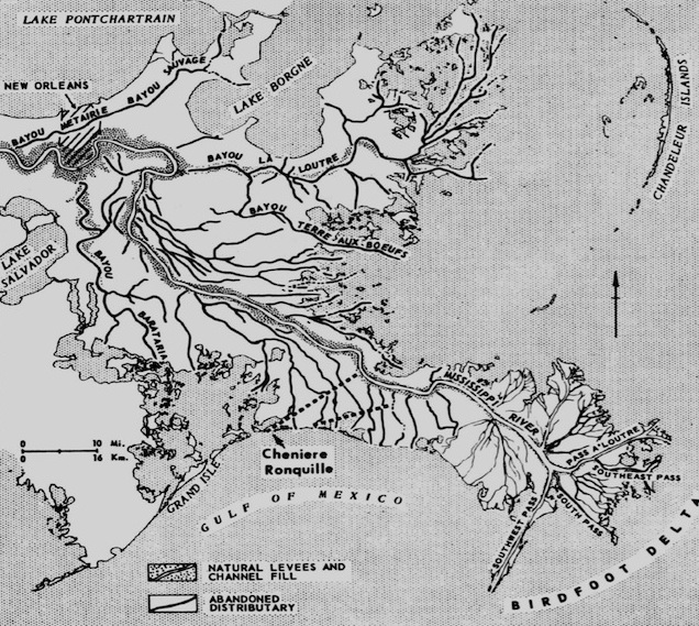
In the Barataria Bay area, Kolker said, the buried bayous are about 10 to 15 feet underground and two to six feet deep.
Kolker calls the subterranean flow a “missing river.” It constitutes “an enormous amount of water,” he said. By his estimate, the flow of water siphoned all across the delta ranges from 35,000 to 110,000 cubic feet per second. The lordly Hudson, as a point of comparison, drives just over 20,000 cubic feet per second past Manhattan and into New York Harbor.
Which brings us to the question on which all science pivots: So what?
Does the “missing river” have implications for public safety or coastal restoration?
The answers to both questions appear to be … maybe.
Comparing river and groundwater levels, the team found that the underground channels fluctuate with the river, acting as an underground release valve when the river gets high.
That may mean that during years the Mississippi River reaches flood stage, the buried bayous could compromise the integrity of the levees themselves as water is sucked under them.
When the river is high, the channels could act as a siphon, especially at elevations lower than the river, Kolker said.
While the U.S. Army Corps of Engineers visually monitors sand boils near the river during high water years, it is harder to know what is happening underground, he said.
In the article he puts it this way:
Groundwater flows in the MRD [Mississippi River Delta] have important implications for engineering geology as fluid flow through buried sand bodies contributed to levee failures during Hurricane Katrina and hundreds of sand boils were reported along the lower MR [Mississippi River] during the flood of 2011.
Then there’s the very contentious issue of what will happen to commercial fishing and shellfish harvesting if more fresh river water is diverted across levees in order to replenish wetlands along the collapsing coast, as proposed in the state’s 2012 Coastal Master Plan.
Oystermen and other commercial interests have sued the state to block these diversions on grounds that reduced salinity will destroy oyster beds and natural fish nurseries.
Kolker speculates that that there is already significantly more fresh water flowing into bays and estuaries than was realized.
So would that impact be compounded by diversions?
Perhaps not, Kolker said. The net impact may be a wash. Because lower river levels reduce the flow of water through the sunken bayous, “there might be less of a difference than people would fear,” he said, adding that the evidence one way or the other is not yet in hand.
Better understanding the function of the groundwater flowing under the delta could also help determine the best places to effectively build land, he said.
The potential chemistry of the missing river is the next line of research, Kolker said. “It could be good or bad.”
The groundwater could be carrying valuable nutrients or harmful contaminants to the bays. Or both. The soil may also act advantageously as a filter, with potential implications for the annual Dead Zone, the lethal, low-oxygen part of the Gulf that in some years mushrooms to a size bigger than Connecticut.
Kolker and his colleagues are not the first to explore the ramifications of fresh water diverted naturally from the Mississippi River. But they are the first, the article states, to focus on “the effects of buried sandy paleochannels” in the delta.
They cite an earlier study that explains the bay’s freshwater imbalance as being the result of “numerous ‘arbitrary streams.’”
“We present here a plausible alternate interpretation that can explain all of these studies,” Kolker and his team assert.
The relevance of continuing research is not limited to Southeast Louisiana, they argue. Deltas commonly serve “as major population centers and conduits for commerce,” the authors write. That means “these results may be applicable to other deltas worldwide, as many of the [world’s] largest rivers have deltas with numerous abandoned distributaries that could act as conduits for groundwater.”
With sea level rising as a result of climate change, the article concludes that “more research is clearly needed to understand how subterranean flow paths and nutrient delivery to the ocean will change during this century.”
In North America’s largest delta, and others across the planet, understanding the role of the missing river will only increase in importance, Kolker said.

