
The new Google app arrived in my life to the kind of reception reserved for a doctor carrying the results of a biopsy. Did I really want to know?
The blog post announced that the God of the Internet had just delivered another digital miracle. It was now possible to watch 30-year time-lapse photography of any spot on the planet. This innovation expands on the phenomenal product named Google Earth, the one that stitches together satellite images of every inch of our world and offers the results for free. No more secrets or surprises.
Now, just by going to Google Earth Engine and searching for a particular location, you can watch what changes time has wrought since 1984, good or bad.
This is the kind of innovation netophiles often liken to a laser beam or well-honed scalpel. But if you’re a resident of southeast Louisiana, it may have the impact of an uppercut delivered with brass knuckles. And that’s probably overdue.
We live on one of the planet’s most abused landscapes, a place that is sinking from human interventions — oil and gas canals and a levee’d Mississippi River — at a time when seas are rising globally. As a result we have lost the staggering sum of almost 2,000 square miles of our coast over the past seven or eight decades, and we face the likelihood of being entirely overrun by the Gulf in 60 years if nothing is done. It’s an onrushing disaster I’ve covered since the 1980s, which, by coincidence, is when the earliest of these satellite images were created.
This hasn’t been just another story to me. The wetlands around our city – the swamps, marshes, beaches and ridges – have been my office, my friends, my playground and my church.
So covering the death of our coast has meant three decades of attending wakes and writing obituaries for important parts of my life. Did I really want to watch a replay of that sorrow? Did I want to renew the hurt and the frustration?
Of course, the journalist in me couldn’t resist; we beat lawyers to car wrecks. And there remained the faint hope that perhaps this latest Google gift could be the teaching tool that will break through the veil of denial most locals still wrap themselves in.
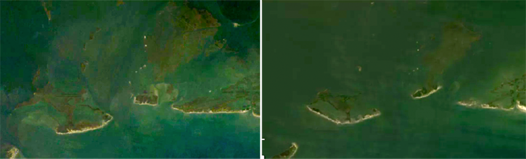
So I clicked on the URL, then moved across the globe to find the southeast Louisiana coast and Four Bayous Pass. This is one of the critical arteries in the circulatory system that brings life to the vast Barataria Bay estuary. It draws the Gulf of Mexico into the marshes on incoming tides, then discharges a richer, brackish mixture as the tide ebbs.
The area has also been a favorite fishing and camping spot for generations of southeast Louisianans and others who flock here from all over the nation and the world. You could tell why at the start of the time lapse back in 1984. Healthy sections of marsh and beach are clearly visible. They delineate the paths of four bayous, while the bay just behind the coast is sprinkled with a string of marsh islands.
Then I pressed the start arrow. I knew what would happen; I’d chronicled it in words and photos for decades. The islands and beachfront would erode northward, the marshes would disappear and the “Four Bayous” would turn into a single wide pass leading to a bay spreading for miles in all directions, uninterrupted by a single blade of marsh grass. This piece of Louisiana’s coastal wetlands, like so many others, would die.
It’s the velocity of the change – 30 years compressed into about four seconds – that turns what seemed like a slow-motion tragedy, a creeping disease, into a sudden act of violence, a drive-by shooting.
Places that created cherished memories are gone. Who could believe anything I remembered without a shred of supporting evidence?
There was also a guilty feeling of vindication. Over the years, people have literally rolled their eyes when I relayed words of warning from scientists about the speed at which this disaster is rushing toward New Orleans. Here was proof.
I began looking for more, paging to other places that were important in my life. The wetlands between Buras and the Gulf: gone in four seconds. The thick marsh and duck ponds west of Reggio and Delacroix: dissolving into open water. My old camp on Cane Bayou off the Wagon Wheel: vanished. The Chandeleur Islands, once a wide string of sandy pearls: shrunk to a patchy, thin line of white thread.
Yet in those sad travels, I also saw something else: signs of hope.
The coastline between Four Bayous and Empire that shrank so noticeably for 25 years has been growing again over the past five, thanks to a rebuilding project pumping offshore sand and sediment onto the beach. The same thing is happening east of Lake Hermitage and north of Bayou Dupont. The spy in the sky doesn’t lie; coastal restoration can happen.
And there is the amazing growth of new land at the mouth of the Atchafalaya River and nearby Wax Lake Outlet. More proof that there’s a way to fight back.
So the sum of this new Google app reads like the bad news in a biopsy; our coast is sick and dying. But the doctor says there’s hope.
It’s worth seeing all of that — right now.
Live chat
Tuesday at 1 p.m., Bob Marshall will answer questions from the public about the challenges facing coastal Louisiana. You can participate below.

