
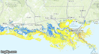
Map makers often use red to denote danger, to sound alarms. But on the latest National Weather Service map showing storm surge in Louisiana from a worst-case Category 3 hurricane, red does one more thing: It shocks.
The red indicates storm surge of greater than 9 feet, and it doesn’t cover just the coastal parishes. It drowns everything in the bottom of Louisiana’s “boot,” from Slidell to Lafayette and north past Baton Rouge.
Things get even worse on the Category 4 and 5 maps.
The maps are part of the Storm Surge Inundation web page developed by the National Oceanic and Atmospheric Administration to help coastal emergency managers and residents assess their maximum vulnerability to storm surge. The web site lets residents on the Atlantic and Gulf coasts check the extent and height of potential surge from the worst-possible hurricane in each of the five storm categories on the Saffir-Simpson hurricane wind scale.*
Areas inside levee systems, such as greater New Orleans, aren’t included because the model could not predict whether the protection would be overtopped.
David Schlotzhauer, hydrologist at the Lower Mississippi River Forecast Center in Slidell, said researchers ran thousands of hypothetical storms through a surge model to get the results.
“Each storm had a different combination of key characteristics, such as wind velocity, track, land speed and size,” he said. “They took the average results of the highest surges from those runs to come up with what we call the ‘maximum of maximums.’ ”
During a real hurricane, the National Hurricane Center would issue storm surge probability maps based on the values for that specific storm, updating and adjusting as the storm moves closer.
Schlotzhauer said that the chance of a “maximum of maximum” storm occurring is rare, but the web page has value in alerting residents and emergency managers to their area’s vulnerability to storm surge, regardless of category.
“A storm means different things to different sections of our coasts regardless of its rating, and people need to understand that,” he said. “For example, during a Category 3, people in Florida people may only have to drives tens of miles to get out of harm’s way.
“But in Louisiana where we have almost no elevation, getting to safety might mean driving hundreds of miles. And different areas even inside a state have different vulnerabilities. That message is clear when you use these maps.”
Hurricane Isaac, a Category 1 storm that struck Louisiana in 2012*, is a recent example, he said.
The theoretical Category 1 map on the web shows most of the coast would get little more than 3 feet of surge. But the Braithwaite section of eastern Plaquemines Parish shows more than 9 feet.
“That’s pretty much what happened to Braithwaite during Isaac,” Schlotzhauer said. “It was a Cat 1, but it was a large, very slow-moving storm on a wrong track for that area. It produced conditions that resulted in maximum vulnerability for that area.”
Louisiana’s coastal vulnerability will only increase in the decades ahead as its landmass sinks and the sea continues to rise due to global climate change, researchers say.
*Corrections: The story originally misspelled the name of the hurricane rating scale. Also, an earlier version of this story incorrectly said Isaac was in 2013.

