If opponents of the sediment diversions in the 2012 Master Plan for the Coast ever write a book about their struggles, they might want to borrow the title from Shakespeare: “Much Ado About Nothing.”
That’s because the Coastal Protection and Restoration Authority says it has yet to decide if diversions will even be built.
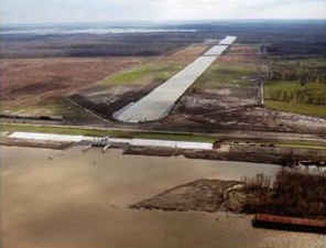
Kyle Graham, executive director of the authority, said his agency is still doing the research to see if diversions could build enough land to offset their financial and social costs, including impacts on fishing communities. And the first call won’t be possible until next fall when analysis of the Mid-Barataria Diversion, planned for river mile 60.7 north of Myrtle Grove in Plaquemines Parish, is completed.
“At that point we should start to know enough about the effects, the size, the costs, the operation regime to have real discussions about whether it’s worthwhile to seek construction dollars toward this project,” Graham said. “Until then we can’t make a decision.”
Asked if his agency would cancel the long-planned project if the research showed the costs outweighed the benefits, Graham said quickly: “Absolutely.”
In fact, Graham said, research underway could settle the debate on “the whole idea” of using diversions anywhere in the plan.
“We have to put this idea to bed,” he said. “Either it is something that continues to be part of [the Master Plan], or it’s something we put on the wayside and we take different strategies.”
[module align=”left” width=”half” type=”pull-quote”]“I can tell you our plan looks very different in 2017 from the 2012 plan — with or without diversions.” — Kyle Graham[/module]Diverting Mississippi River water and sediment through the levees has long been a centerpiece of plans to rebuild the state’s sinking and crumbling coast. Five sediment diversions are in the 2012 plan, but more money is dedicated to marsh-rebuilding projects that use dredges to pump sediment from the river into the basins via pipelines. Diversions could cost as much as $650 million each, depending on their size.
Pipelines build land quicker, but they must be rebuilt from time to time because the new land eventually will subside. Diversions cost more to construct, and they build land more slowly — but will function as long as the river flows.
Opposition to diversions has been mounted mainly by some fishing groups worried that changes in water salinity would relocate their target species. They prefer the pipelines, which they say would not cause as much fisheries disruption. Some have also charged the coastal agency with deciding on diversions without considering the consequences.
Not so, said Graham. In fact, research on diversions funded by monies from the Deepwater Horizon disaster is focused on settling long-standing scientific and engineering questions about the efficacy of diversions.
“Diversions have been a part of almost every plan proposed for the coast going back decades, but we’ve never really been able to answer some of these questions until now,” Graham said.
The research focuses on two broad questions: where best to capture what the river has to offer, and what the impacts could be on the marshy basins beyond the river levees.
Measuring the impacts on adjacent coastal lands has been the most challenging part of the research. Using suites of computer models, researchers are trying to determine:
- How quickly land could be built
- Which types of existing marsh habitat best trap sediments
- The impact on fisheries
- Impacts on fishing communities
- Impacts on flood-protection levees in communities adjacent to the receiving basins
And all of those impacts must be calculated for diversions of different sizes.
Planners will take the results and weigh the land-building potential against costs.
For example, a large diversion at Myrtle Grove — 250,000 cubic feet per second — might build more land and build it more quickly than a mid-sized diversion. But some model results show pouring that much water into Barataria Bay could cause flooding in Lafitte. Abating that threat by increasing flood protection for Lafitte could push the cost of the diversion too high.
Planners currently are “zeroed in” on a diversion near Myrtle Grove that siphons 75,000 cubic feet of river water per second, but a decision is still months away – whether for a diversion of that size, or any diversion at all, Graham said.
“So we are very much still in that process of looking at alternatives for Mid-Barataria,” he said. “This is a very time-consuming process because it has to be. We run one set of options and get one set of results. Then we say, OK, what if we change this?
“We’re making sure we are vetting all the possibilities.”
Graham said his team is excited about answering the diversion questions.
“Is it possible to take these diversions and make them and continue to be a centerpiece of our Master Plan?” he said. “That’s what is really kind of driving us. I think we owe it to the public and all of the folks who have worked in the coastal realm for the last several decades to truly try to figure this puzzle out the best we can.”
While acknowledging that many people assume the diversions are a fait accompli simply because they are listed in the 2012 plan, Graham stressed the public should remember the whole effort is based on adapting to changing knowledge and circumstances. The agency must submit an updated plan to the Legislature every five years.
“I can tell you our plan looks very different in 2017 from the 2012 plan — with or without diversions,” he said.
Graham said if a decision as made in late 2015 to go forward with the Mid-Barataria project, its earliest possible operating date likely would be 2020. Sites have yet to be finalized for the other four diversions in the 2012 plan.
