What’s more worrisome?
- A. The Army Corps of Engineers is repairing a newly-built levee that has subsided as much as six inches — the second such repair in a year and just as the state is about to take ownership of the $14.5-billion system.
- B.No one with the regional Flood Protection Authority was surprised. In fact, they’ve been expecting this news.
Welcome to life on a starving, sinking delta – in the middle of Hurricane Alley.
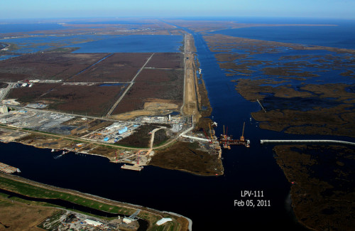
Officials recently discovered that a 1.1-mile long stretch of the levee along the Gulf Intracoastal Waterway had sunk 3 to 6 inches below its design height of 25 to 27.5 feet. It will cost about $1 million to repair, according to the Corps of Engineers.
“Actually the corps has estimated it will probably cost about $35 million over the next 10 years to keep this system certified for flood insurance,” said Tim Doody, president of the Southeast Louisiana Flood Protection Authority-East.
“I mean, anyone who lives here knows this is a problem. We certainly do, and it’s one of the biggest challenges for us going forward.”
Delta sinking all the time
The cause of the problem is simple and well-known. All of southeast Louisiana consists of deltas made of sediment laid down by Mississippi River floods over the past 7,000 years. The sheer weight of that massive layer of soft mud, 400 feet thick in some places, causes it to constantly compress against the bedrock far below. If new layers of sediment are not added, subsidence begins.
New sediment layers were blocked in the 1930s when the Corps of Engineers completed a system of world-class levees to keep those river floods from damaging communities.
But if the cause of the problem is simple, the way it unfolds locally has a complexity that makes fighting subsidence more challenging here than almost anywhere on earth, engineers say.
As our delta was built over the millennia, different parts were covered at different times by a variety of surface features, ranging from marshes to beaches to swamps to forests. Over time, more sediment buried these surface features and new ones emerged.
The result is a complex weave of different types of soils — soils of varying thickness, compressing at varying rates.
“We might have one section of levee sink rapidly over a period of months and another next to it sit perfectly stable during that time. … You can make your best guess at what’s going to happen – but that’s all you’ve really got: guesswork.”—Stephen Estopinal, Southeast Louisiana Flood Protection Authority
So not only is the entire landscape settling at one of the highest rates on the planet, it’s happening at different rates across the landscape. Worse, for builders, those different rates can take place over a few yards, not a few miles.
“We know there will be subsidence, but there is no predictability about the rate of subsidence over distances here,” said Stephen Estopinal, a civil engineer on the board of the Flood Protection Authority. “We might have one section of levee sink rapidly over a period of months and another next to it sit perfectly stable during that time. Then the reverse will happen.
“You can make your best guess at what’s going to happen – but that’s all you’ve really got: guesswork,” Estopinal said. “This place is moving in three dimensions all the time, so you’ve got to stay vigilant.”
J. David Rogers, a forensic engineer who worked on the postmortem analyzing why and how levees collapsed after Hurricane Katrina, famously summed up the challenge of levee-building here this way: “It’s like putting bricks on Jell-O.”
The analysis concluded that Corps of Engineers of the 1980s hadn’t studied the Jell-O thoroughly enough and chose the wrong kind of bricks to put on it.
Post-Katrina vigilance
Unlike the levee boards that it superseded, the Flood Protection Authority was required to put engineers and other professionals on its board, and it has monitored construction of the new system to make sure the same mistakes are not repeated.
The corps, too, is more vigilant now. The agency has done extensive work to get a better profile of soils under the entire system. And it builds levees taller than required in anticipation of their predictable subsidence.
But both the corps and the Flood Protection Authority know that local subsidence can outfox even the best-laid plans.
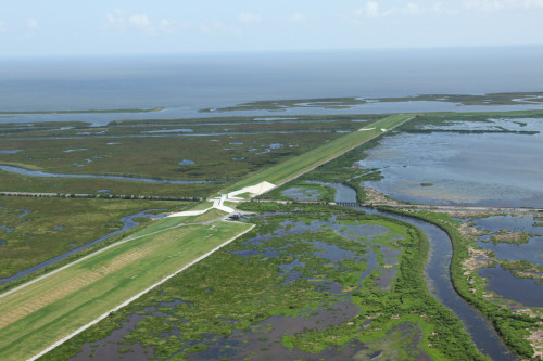
The levee along the Gulf Intracoastal Waterway is a case in point.
Chris Gilmore, the corps’ senior project leader for this section, said not only were extensive samples taken to discover what types of soils underlay the levee, but the entire stretch was built on a type of cement pilings. The corps injected concrete into holes in the soil and built the levee on top.
“It’s what we call deep-soil mixing,” Gilmore said.
And yet, a final inspection before handing over responsibility for the levee to the Flood Protection Authority revealed that a 6,000-foot stretch tied into the Lake Borgne Surge Barrier was 3 to 6 inches lower than the 25 to 27.5 feet it was designed to be.
The predicted rate of subsidence had been exceeded, and no one was really surprised. A year earlier, the corps discovered that a stretch of new levee between U.S. Highway 11 and Interstate 10 had dropped a startling 3 feet more than expected. There, design elevations range from 16.5 to 25 feet.
“As most folks who live in the area know, the ground in Louisiana is always sinking,” said Gilmore. He estimated the 6,000-foot fix will cost about $1 million and take two to two-and-a-half months to complete.
350 milesLength of storm protection system$38 millionCost to maintain it over 10 years
The impending change in ownership means the local flood authority – funded by property taxes – will now be responsible for the cost of shoring up sinking levees. The tab won’t be chump change.
Corps of Engineers spokesman Ricky Boyett said the agency estimates the cost for “Operation, Maintenance, Repair, Replacement and Rehabilitation” will be about $38 million over the next 10 years. He said that figure was for the entire 350 miles of levees, floodwalls and associated structures such as floodgates.
The contract between the Corps of Engineers and the state seems to offer a loophole to local agencies. It states that the agreement is not intended “to require the Non-Federal sponsor to perform future measures to restore the New Work to the authorized level of protection to account for subsidence or sea level rise,”
But Doody said the Southeast Louisiana Flood Protection Authority-East wasn’t counting on that as an escape clause. First, the agreement doesn’t require the corps to do the work. Second, Congress hasn’t appropriated the money.
“We can’t sit around and wait for someone to settle the issue; we have to make sure we keep this system certified,” Doody said.
There is one thing they can be certain of: The flood authority’s new levees, like the rest of southeast Louisiana, will continue to sink.