If you’re a cyclist or runner tired of waiting to use the path along the Mississippi River, you should get used to it.
The section from Audubon Park to the Jefferson Parish line that looked finished weeks ago will remain closed for another six weeks. The asphalt path was built without the appropriate shoulder needed for safe use by cyclists and runners.
And the other nine miles from the Riverbend to the airport will be closed at different times over the next two years as the corps raises the levee.
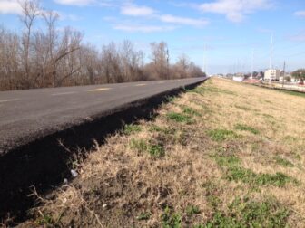
U.S. Army Corps of Engineers spokesman Ricky Boyett said that on the Uptown portion of the path, there’s a drop of 8 to 10 inches from the path to the grass. The problem was discovered when the corps was inspecting the project, he said.*
The agency is working to bring up the shoulder. “We will not open the path until that drop is eliminated,” Boyett said.
The work is part of a major project to raise levee sections two to three feet to address subsidence that has occurred over the decades. The remaining construction will occur in two sections:
-
A 4.2-mile stretch from the Orleans Parish line upriver to Crislaur Avenue
-
A 4.5-mile stretch from Orchard Road upriver to the St. Charles Parish line
Each section will be closed for about a year. The levee between Crislaur and Orchard is already high enough.
According to Boyett, the corps has begun breaking up the bike path starting from the Orleans-Jefferson parish line and moving upriver. At present the work area is fenced off from there to the upriver end of the Ochsner medical complex, less than a mile away.
People who ride and run on the winding, 30-mile-long asphalt path from The Fly at Audubon Park to the Bonnet Carré Spillway may think it was built just for them.* But according to Boyett, the path is there to allow the corps to move heavy equipment for levee inspections and repairs.
“We don’t have to be on it all day,” he said, “so there is no harm in allowing the public to use it for recreational purposes.”
The only time the path would be shut down, Boyett said, is if the corps needed to use it to prepare for an impending flood. Otherwise, the public has full access to the scenic road — in Orleans Parish, that is, starting sometime in March.
*Correction: This story originally reported that the corps was fixing the path in response to people’s complaints. The problem actually was discovered during the inspection process. The story also implied that the path ends at the St. Charles Parish line, but it extends to the Bonnet Carré Spillway. (Feb. 4, 2014; Feb. 24, 2014)